We’re approaching the time in my trip when all of my best friends start leaving I get sad and have to begin the whole friend-making process again. Ugh. Hopefully I can manage to keep myself from falling into a moody depression like what happened in Ghana. I think I’ll be okay, but still, I’m not excited about having to find new people who are on the same page as me. It’s not as easy as you might think.

Walking into Dilijan (the town)

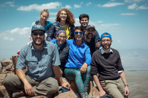
Anyway, the point of that whole rant is that the first person from our crew to leave was Shant, and his final wish was for us to go hiking and camping in Dilijan National Park. Dilijan is a 240 square kilometer national park. It was established as a nature reserve in 1958 and was changed to a national park in 2002. You know what the best part of Dilijan is? THERE ARE TREES! Yeah, yeah. I know that sounds stupid, but I miss forests. Dilijan has plenty of trees, and it made me very happy.

This is Sharambeyan Street in Dilijan. It’s been preserved as basically the Dilijan “old town”. There are different kinds of artisan shops all the way down the street which is pretty cool.

Are you ready to hear a ridiculous story that supposedly explains the origin of the name “Dilijan”? Once upon a time, there was a shepherd named Dili who fell in love with the daughter of his master. Obviously, since this is how these stories go, the master was wholeheartedly against it and ordered Dili killed! Seems like a dramatic response to me, but well… yeah. Anyway, Dili’s mother searched for him for days and days, wandering around and calling out “Dili jan! Dili jan!” (If you recall, people use “jan” as a term of endearment after someone’s name or sometimes just in place of it.) The End. Hehehe that might be one of my favorite Armenian stories yet.

Along the hike!

Anyway, one of our friends from Gyumri is spending a month working with the Transcaucasian Trail. They’re planning to build over 3,000 kilometers of trails in Armenia and Georgia. It’s going to be super cool! (If you want to see the route or read more about it, check out their WEBSITE.)  It’s also going to take nearly forever, but still, anything is better than what they have now. As you may have realized from my many posts about “hikes” I’ve gone on with my friends, there are a ton of cool places to hike here, but very few of them have actual trails, and even fewer have trail markers. Armenia has a lot of potential as a tourist destination for people who are into outdoorsy activities, but it’s much easier to sell that when you have accessible information and actual official trails.

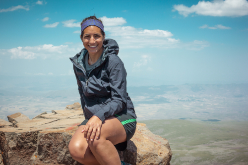
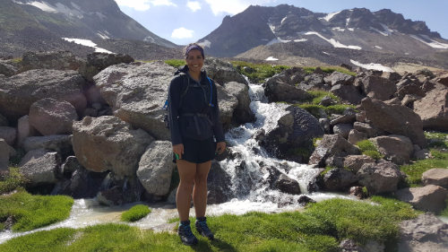
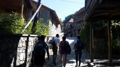
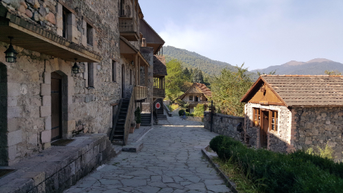
Dilijan is beautiful!! It was on my list of places to definitely visit, so when Shant said that he wanted to go there, I was all about it. We got in touch with our Dilijan friend, and she said that we could camp behind their house and borrow camping equipment. Nice! I’m pretty sure that you can probably just pitch a tent wherever in Dilijan, but this way we didn’t have to worry about renting equipment and carting it with us.

This was the marshrutka on the way back to Yerevan. I was confused about why they had these little cubes inside. They looked like footrests. Nope. They were seats. Gotta pack the people in!

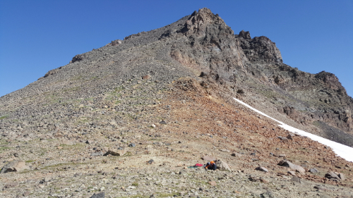
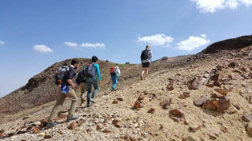
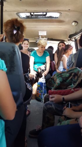
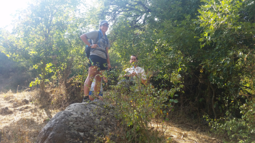
We took the first marshrutka from Yerevan at 9AM and were in Dilijan by 11. After stocking up on snacks and supplies, we walked to the campsite and got our tents set up before heading out for a hike. Since the trail marking is still a work in progress, there aren’t many well-marked options. They have all sorts of maps in the TCT headquarters of the various jeep trails and such that exist around the park, so one of the guys there showed us a route that we could take that had no markers but used existing paths. He said it took him 5 hours which I took to mean it would take us at least 7. He tried to insist that he wasn’t going fast, but that means nothing when you’re talking to someone who hikes all the time. We decided to give it a try, I confirmed the directions to the trailhead about 50 times and took a million pictures of the map, and we were off.

A tiny church along the way

I hate being the navigator. Okay, that’s not a completely fair statement. I like navigating and I’m good at following maps, but depending on who you’re with, having the navigating responsibility can be stressful. If I was with Sarah (best friend Sarah), for example, it would be fun. If we hit a point where we weren’t sure which way to go, we would just try one and turn around if it was wrong, no big deal. It’s all part of the adventure.

The view from the top.

Sometimes though, people see pauses and uncertainty as you not knowing what you’re doing, and they lose all confidence in your guidance. That’s when I hate navigating. Following hiking maps isn’t quite as easy as street maps, so sometimes you need to just take an educated guess. There were some parts where I wasn’t completely sure about where EXACTLY we should be walking, but I knew that we were following a river the whole way, so as long as we were close to the river, we weren’t lost.

The crew! Laura (Carineh’s friend who came to visit), me, Carineh, Gagik, and Shant

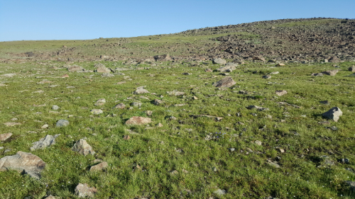
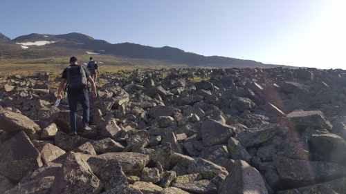
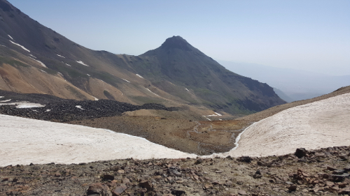
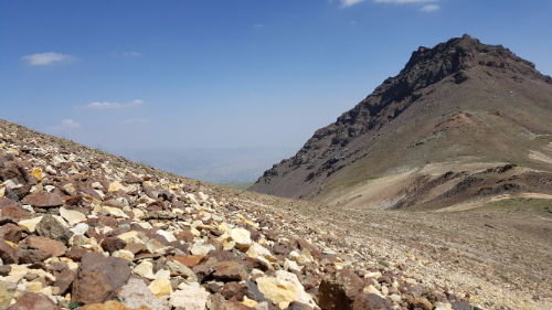
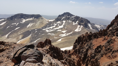
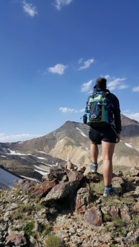
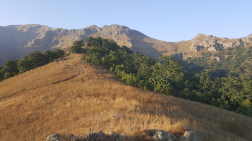
There was only one part where the “trail” shown on the map wasn’t even close to right. Otherwise, we made some slow progress, but I always knew where we were. We made it to the halfway point after about 3 hours, and I knew there was no chance that we were making it all the way to the end before it got dark. That dude who made it in 5 hours must have been some sort of mutant. Called that. We made a group decision to go a little bit farther so that we could get a good view and then turn around and head back. At least then we would be following a path that we had walked before, and I had a GPS tracker running so we could use that to make sure that we were going the right way.

Tired and happy

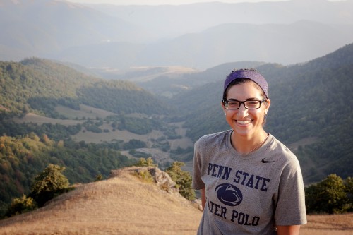
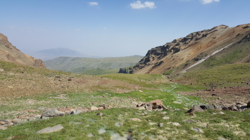
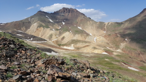
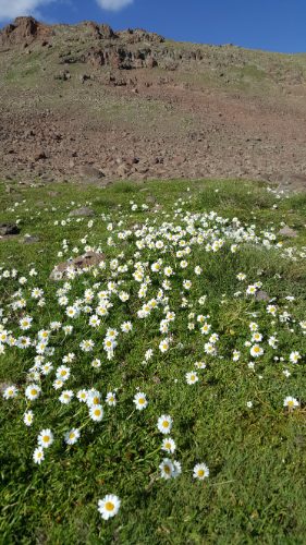
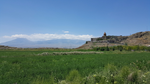
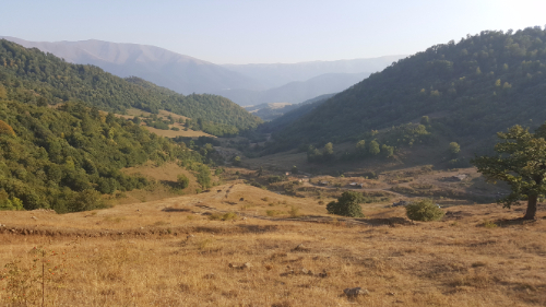
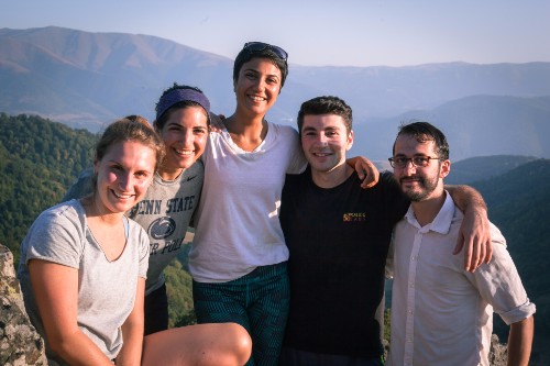
The view from the “end” of the hike was awesome. There was a great view of the valley, some mountains in the distance, and there were even a few trees starting to change colors already! It would be super cool to go there in the middle of fall with all of the leaves changing.

After spending a little time resting and enjoying the view, we started hightailing it back in an attempt to hit the road before dark. We had flashlights with us, but that’s no good when you’re not following a clear path. There were a few parts of the hike where we were walking through fields, so you had to be able to see ahead across the field to make sure you were walking in the right direction. We were about 5 minutes from the road when it got completely dark, but luckily that was close enough. The whole hike ended up taking something like 5-6 hours, and I was wiped by the end.

We ate dinner in town at the one restaurant everyone always talks about before heading back to the tents. And s’mores. Because what is camping without s’mores? We didn’t last very long after getting back… I think everyone was exhausted. I could have slept on a bed of rocks.

Here’s our taxi driver looking at a map while driving. Comforting, yeah?
Me, looking like I’m haunting Carineh. And a mystery person looking like they’re haunting me… though I don’t think you can see it that well. Just know that there’s someone else lurking there who looks even creepier than I do.

Last weekend’s adventure was hiking the northern peak of Mount Aragats! Aragats was created by a volcanic eruption and is now a huge crater surrounded by four peaks. They’re creatively named the northern, southern, eastern, and western peaks, and the northern peak is the highest point in Armenia at an elevation of 4,091 meters (13,420 feet).

This is what most of the beginning of the hike was, as we made our way past the southern peak

It has also been an important symbol for Armenians since the pre-Christian days and has pagan and Christian shrines scattered around. Many of them are hidden, and according to the legends, some are hidden using methods more magical than simple camouflage. Remember our friend St. Gregory? The one who lived in a pit for years and helped to convert the Armenian king to Christianity in 301AD? Well, he was a VERY busy guy because he also used to climb Aragats pray and at night was guided by a lantern “hanging from heaven”. The lantern supposedly still appears on the mountain, but only the worthy can see it.

Big rocks!

When Sarah and I went on that tour in Yerevan, the tour guide talked about how he and some friends hiked the northern peak, and from that moment, I decided that I was going to do it if I got the chance. I didn’t know at the time if I would find any friends who liked to hike, but I was hoping! Sure enough, about a week into being in Gyumri, I heard about a group forming to hike it, and I signed myself up. I was worried because I hadn’t really planned on doing any serious hiking while here, so I didn’t bring my hiking boots. It was hard to find any real information online about the hike, but from the people we talked to and the information we got from the guide, it sounded like boots would be a good idea. I ended up being the absolute luckiest because a friend was coming to visit Armenia the week before the hike, and she brought my boots with her! I’m telling you, if you ever do this hike, boots or hiking shoes with a hard sole and waterproofing are essential! We even hiked it at the time of year when there’s the least snow, but it doesn’t matter. Trust me.

The western peak from the low-ish area between western and southern

We set out from Gyumri at 4:15AM, and yes, that was as miserable as it sounds. My host mom was sure that I was saying the wrong number when I told her when I had to leave the house and then told me to have fun and that she would still be sleeping. The drive to Kari Lake, the spot where the hikes start, takes a little more than 2 hours from Gyumri, and it took us even longer because the taxi drivers needed to take a couple smoke breaks, we hit an animal on the way, and we got stuck behind some farm equipment. Off to a good start.

The eastern peak and the first snow patch that we had to cross.

The hike is supposed to take like 8-16 hours or something like that. We were shooting for finishing it in 10, but I had no idea what to expect. Thankfully, we had a guide, so we didn’t really have to know much. I totally didn’t realize how much hiking you have to do to just to make it to the base of the north peak. We set out from the lake, walked past the southern peak, and crossed into the crater through the low-ish point between the western and southern peaks. When I realized that all of the hiking up we had done wasn’t even the beginning of the hike to the peak, I was horrified. We had to hike down into the crater before hiking all the way up again. It took us three hours just to make it to the base of the northern peak.

Making our way down into the canyon

After a break, we started to make our way up. The terrain was basically all rocks. Little rocks and medium sized rocks with sporadic plants. The lack of much plant growth and dirt to hold the rocks in place meant that every step was a potential rock slide. Perfect. This is where the recommendation to bring hiking poles started to make sense. You should bring hiking poles. It’s certainly possible without them but I would estimate approximately 10000x easier/less terrifying with them.

Multicolored stones!

The first half of the hike up to the peak isn’t really that bad. It’s steep, but you can find paths where the rocks aren’t as unstable, and the only part of me that was getting tired was my calves. We stopped to take a break in the least comfortable location (imagine like a 45-degree slope with sharp rocks poking into you) before starting the second half. From that point on, it was way worse. The inclines were steeper, the rocks were smaller and less secure, and the drop offs were mildly terrifying. I’m not afraid of heights, but I am afraid of rock sliding down the side of a mountain. I’m not a fan of feeling like I can’t trust my feet to stay where I put them, so I started going extra slowly. The other people in my group must be half mountain goat because none of them seemed to be that bothered by it (though I’m sure that’s partly because if they were nervous, they just didn’t show it). I let them go ahead of me because, in that kind of situation, I don’t like feeling rushed or like I’m holding people up. I knew that I would make it to the top, it was just a question of the speed at which that would take place.

View from the top!

I think it took us something like 3 hours to make it to the top. Everyone else could have probably done it in 2-1/2 or less, but I was definitely the weakest link in that situation. Fear is a really interesting thing. There are so many things that I’m not afraid of, and there are a lot of similar situations where I would be completely fine. I think that in that case, it was a combination of having a couple foot slips that freaked me out, not wanting to slow down the group (though that happened anyway), and feeling a little unbalanced because of the altitude. I never had the thought that I couldn’t do it or that I should turn around; I just needed to do it my own way and to go at my own pace.

The crew

The view from the top was awesome, and the feeling of making it there was even better. I chose to ignore the fact that I was also going to have to make it back down because I didn’t want to spoil the moment. We sat at the top, ate some snacks, and enjoyed the views of the other Aragats peaks and the surrounding landscape until the guide insisted that we start heading back down.

At the top!!!
Mid-hike snowball toss

I took my place at the back of the group to avoid slowing anyone down, and the guide came over and offered me his hand. I knew that I could make it down without any help, so the choice was really just between 1) insisting on doing it myself, slowing down the group even more, and feeling terrified the entire descent and 2) accepting some help, moving at a reasonable speed, and feeling slightly at ease. I’m all about doing things for myself, but there’s also no shame in accepting help when it’s offered. I took his hand, and he basically dragged me down the mountain.

Going up again…

At the bottom, we had to decide how we wanted to get back to the lake. The “fastest” option won, but fastest definitely didn’t mean easiest… in this case, it meant steepest. There’s nothing worse than finishing climbing the mountain that you came to climb just to realize that you need to climb two more mountains to get home. We went up and down FOUR times on the hike. The actual northern peak part of the hike was definitely challenging, but if that was all you had to do, it wouldn’t be bad at all. We spent more than half of the total hike time going to and coming from the base of the mountain!

Kind of like paradise…

We had one river, two more aggressive uphill climbs, three snow patches, and seemingly endless wildflower spotted fields to make it through before the end of the hike. For all of that though, I was fine mentally. It was just something about the sliding rocks on the north peak that got me into a funk.

Me in the oasis
There she is… the northern peak
Me looking much more epic than the reality
So many wildflowers!

When we made it back to the lake, I wanted nothing more than to go to sleep. The whole hike took us about 11 hours and 20 minutes, including our million breaks and my pokiness on the way to the peak. All things considered, I thought that was pretty good. We loaded back into the cabs and made our way down the windy roads down the mountain and home to Gyumri. I got home a little after 10PM and went immediately to bed. I must have looked a mess because my host mom didn’t even try to force feed me when I said I just wanted to sleep.

All in all, I’m glad I did it, and even more, I’m glad that I never have to do it again.

P.S. If you ever find yourself planning to hike the northern peak, talk to me. Hiking boots. Hiking poles. Late summer. Lots of water.

One thing that there’s no shortage of in Armenia is churches. We wanted to go to Etchmiadzin (basically the Vatican of Armenia), and we decided to turn it into a full-on church day.

Etchmiadzin. Probably would look cooler without the scaffolding, but what can you do?

Etchmiadzin is located in Vagharshapat, a town about half an hour west of Yerevan. Even though the town isn’t that big, there are five churches there (including Etchmiadzin which is like a little church city), so we decided to visit them all. Why not, right?

Church of Saint Gayane

We did the usual routine, taking a city bus to a marshrutka station and getting a marshrutka from there to Vagharshapat. The churches we were planning to see were kind of laid out in an L-shape, so we started at one end of the L and worked our way through. The first stop was the Church of Saint Gayane. It was built originally in 630AD and had some renovations done in 1652. Just pause for a second… That. Is. Ridiculous. I don’t know about you, but I think that St. Peter’s (the Vatican) is old, and construction on that didn’t start until the 1500s! Also, the fact that they went over 1000 years without needing renovations, and that after 1000 years they just did some work on the dome and ceilings, is crazy. Who knows, maybe it’s not as impressive as I think, but it sounds pretty good to me!

Lots of curved and perfectly fit together stones.

Anyway, do you want to hear the story of Saint Gayane? Because obviously she has a story because everything is part of a long, interconnected history here. Get ready for your head to hurt a little. Remember how I talked about St. Gregory? The guy who was imprisoned for 13 years in the pit in Khor Virap and was only freed when the king went mad? Well, the reason why the king went mad has something to do with both Saint Gayane and Saint Hripsime, the namesake of church #5 in our Vagharshapat church tour. (Note: this is another one of those stories that definitely has a certain amount of fact in it but has also certainly been embellished over the years. You can decide what you want to take and leave.)

The word is that Gayane was the head of an abbey of nuns in Rome, with Hripsime included. Hripsime was very beautiful, and Diocletian, the Roman emperor, noticed her and wanted to force her to marry him. The entire abbey of 30-some nuns fled Rome and ended up in Vagharshapat. There, Hripsime attracted the attention of yet another unwanted suitor, King Tiridates III, the same king who St. Gregory helped. When she refused his advances, she and the rest of the nuns were tortured and martyred. Some stories say that the king also fell in love with Gayane, and she also refused him. The exact facts on this are a little unclear, as are the exact methods of the martyring. Both Saint Gayane and Saint Hripsime’s churches are supposedly built on the sites where each woman was killed, and the rest of the nuns were killed at the future site of Shoghakat (church #4 on the tour). I read somewhere that Saint Hripsime was stoned, and her church supposedly has some of the actual stones that were used. Who knows if that’s true, but I can attest that there’s a little glassed-in alcove in the wall near her tomb with some rocks in it. Anyway, these women are considered the first Christian martyrs in Armenia’s history.

Sarah’s beloved doors

After killing a bunch of nuns for doing nothing wrong, the king went crazy (with some stories saying that he literally turned into a wild boar or that he had a boar’s head), and that’s when St. Gregory came in and saved the day and Armenia became the first Christian nation. So really, these women deserve the credit for turning Armenia into the country that it is today, though it would have been nice if they didn’t have to be murdered for that to happen.

Saint Gayane’s church is beautiful. It’s the same style as so many other Armenian churches, but I still think they’re all super cool. The doors are wooden and covered with insanely intricate carvings (Sarah closely examined and marveled at a door for a solid 5 minutes: “This is WOOD??! And someone carved it like THIS? What if they messed up? How did they do this? THIS IS AMAZING. This is WOOD??”) The inside of the church is simple, but it’s still impressive when you think about the fact that it’s stone, and all of those stones had to be shaped and fit together perfectly to make all the curves and arches.

Etchmiadzin (church #2) was up next. Guess who is involved with the story of Etchmiadzin? If you said “St. Gregory”, you win! St. Gregory had a vision of Jesus Christ descending from heaven and striking the site with a golden hammer, so that’s where the cathedral was built. Etchimiadzin means “where the Only Begotten descended”. It was originally built in 301AD and is considered the oldest cathedral in the world, but it has been destroyed and rebuilt many times since the original. It is the headquarters of the Armenian Apostolic Church and is where the Catolicos (like the Armenian pope) resides.

The inside of this church was anything BUT simple. Everything was beautifully painted, and Sarah and I sat on a bench inside and just stared at the walls and ceilings until we felt ready to leave. It was beautiful. Check out the pictures because words aren’t sufficient.

Talk about epic doorways…
Simple, right?
My new most favorite ceiling in the universe.

Church #3 was Holy Mother of God Church. No crazy story with this one. There was an actual service going on when we visited, so that was fun to see. That also means I don’t have any pictures though, so you’ll just have to go for yourself if you want to know what it’s like.

This is a park in Vagharshapat. Some kids were playing in the far fountain, and Sarah and I were about 5 seconds away from joining them to escape the heat. This park is also funny because there are all of these little church replicas around it, so we did a mini-church tour in the middle of our human-sized church tour. You can see a couple in the cases on the left side of the picture.
I laughed at this. There are a bunch of churches where I’ve seen similar things, and maybe you won’t think its as funny as I do… but instead of using light bulbs that look nice and match the chandelier, they have these icky spiral compact fluorescent bulbs. I mean, good for them for trying to save energy, but it is possible to do that without sacrificing aesthetics. Okay, rant over.
Intense dragon drainpipes

Church #4 was Shoghakat, the site where the remaining nuns were martyred. That was probably the smallest of the five churches, but it was still interesting to see and compare it to the others.

Shoghakat
Saint Hripsime

Finally, church #5 was St. Hripsime’s church. It’s definitely one of my favorites if you’re going off of exterior appearance, and the fact that it’s basically sitting on a pedestal probably helps. It makes the church seem so much more commanding because it’s raised up above the surroundings, and nothing is impeding your view of it. The inside was simple again, but very pretty. I think it was set up for a wedding or something because the aisle was lined with candles and flowers (Sarah and I approved… they looked nice). We popped our heads into the tomb to see the glass-encased stones and then high-tailed it out of there because it felt weird.

The candles are a nice touch, right?
This is from the back of the building, but you can get an idea of the mosaic work from the dome.

When we got back to Yerevan, we stopped by the Blue Mosque, the only active mosque in all of Armenia. It avoided the fate of other mosques because it was temporarily the History Museum of Yerevan. It seems like temporary repurposing is the only way that religious buildings make it through tumultuous times. We only snuck into the complex for a couple of seconds because it technically wasn’t visiting hours, but the mosaic work on the mosque is awesome.

Last stop was St. Gregory the Illuminator Cathedral (yes, as in our BFF St. Gregory) which is the biggest Armenian church in the world. It was finished in 2001 for the 1700th anniversary of Christianity as the state religion of Armenia. It is massive, obviously, and very simple inside except for a crazy big chandelier that I didn’t feel comfortable taking a picture of at the time. I could probably go into more detail, but I’m exhausted just writing this, and I’m sure you’re exhausted reading it. Gosh, Armenia. You have too much history!

I don’t know that this picture conveys the scale or epic-ness of this church, but just trust me, it’s huge.

Congratulations, you’ve now virtually visited EVERY mosque in Armenia and six of the 1 bagazillion churches in Armenia. How does it feel?

Sarah looking awkward in the metro

Sarah and I are basically public transportation pros now. We’re all about economical travel which means things are never easy or straightforward and always weird and memorable. The goal of the day was to make it to Khor Virap, a monastery about 30km south of Yerevan. The trek started with a walk from our apartment to Republic Square (the central square in the city) to catch the metro.

The metro here was built when Armenia was part of the Soviet Union. Cities with at least 1 million residents were granted a subway, so even though a population of that size wasn’t in the original plan for Yerevan, the quota was reached, and a subway was built. There’s only one metro line and the route is kind of random, but if you’re starting and ending somewhere close to the line, it’s actually very nice. The stations are way cleaner than any other subway I’ve ever been in. A ride costs 100 drams (about 20 cents), and to pay your fare, you buy these little plastic tokens that look like someone cut them out of a sheet of plastic using safety scissors.

The ride back to Yerevan. Spot the Sarah.

Our metro ride was uneventful, and we made it to the bus station quickly and without any trouble. The next part of the trip was taking a marshrutka (that’s the Russian word for it… I’m sure there’s an Armenian word too, but this is the one that I’ve heard used) which is basically the exact same thing as tro tros in Ghana and combis in Peru. They’re minibuses that (generally) look like they’ve seen MANY better days, and everyone packs in like sardines. I wouldn’t recommend it to anyone with a strong need for personal space.

It was easy enough finding the right one to take. I let Sarah think that my Armenian reading skills were really good, but actually the sign also said “Khor Virap” in Latin letters too. Shh, don’t give away my secrets. Actually though, I can read at least well enough to make sure we’re going the right way. I didn’t realize how big of a help that was going to be.

The bus left exactly on schedule which impressed me. Is “Armenian time” just an excuse that people use in the States to justify being late, but it’s actually not a thing in Armenia? Or maybe the public transportation is just on point here. I’ll have to get back to you on this.

Khor Virap from afar

We made it to Khor Virap in maybe 40 minutes, and the driver took us all the way to the parking lot even though the route is supposed to leave you off about 1.5 km away. That was fine with me! He saved us 20 minutes of walking each way, and we used that time for extra adventures. The first stop though, obviously, was the monastery. There are two reasons why this monastery is extra cool. Reason #1: you get an awesome view of Mount Ararat. Reason #2: legend has it that St. Gregory the Illuminator was imprisoned by the king for 13 years in a “dungeon” (aka a creepy underground room or a “khor virap” – a “deep well”) in the monastery. He was left there to die and was even forgotten by the king, but he was fed and kept alive by a woman from a neighboring village (I’ve heard this a couple ways though… one is that it was one woman under the influence of a strange dream that compelled her to bring him food. The other is that it was a few Christian women who secretly fed him. The length of the imprisonment also seems to be up for a bit of debate with some sources saying it was only 13 months, not years, but we’ll go with years because that’s a better story).

Sarah looking excited about coming down the ladder into some random hole. Why does one monastery need so many holes?
The random hole, purpose unknown (by me, that is. I’m sure someone knows).
The ladder out of the imprisonment hole. It smelled nice and musty down there, as I’m sure you can imagine.
Surp Astvatsatsin Church in Khor Virap

Eventually St. Gregory was freed when the king went mad, and his sister had a dream that St. Gregory could cure him. And that is how this story goes from being just about St. Gregory to being the story of how Armenia became the first country to declare Christianity the state religion in 301 A.D. If you know any Armenians, then you know how proud everyone is of that fact, which by association makes Khor Virap kind of a big deal. Wow. Sorry, that story ended up being much longer than planned (and I cut out a LOT of details, trust me). Anyway, the takeaway from this is that Armenian legends are great, and who knows what’s true and what’s not quite. I’m going to count them all as completely factual because that’s way more fun.

Check out that view! Hi, Mount Ararat!
Us with Gervorg

After exploring all of the nooks and crannies of Khor Virap, we still had some time before our return bus. We headed out on a pilgrimage to a statue of Gevorg Chaush, a guy who I think would be best described as a freedom fighter (correct me if I’m wrong). We thought it was funny that there’s a statue of him basically in the middle of nowhere, so we made the trek out to give him a little company.

Thankfully, we made it back just in time to catch the bus which was, once again, EXACTLY on time. Incredible. We got back to Yerevan and spent some time at the Armenian History Museum. Here’s the quick summary: The Armenians have been around for practically forever (they say that there’s been a geographical region called Armenia for 2600 years). There’s a LOT of history to go through. You can see the oldest shoe in the world that’s dated back to about 3500 BC (that’s even older than the pyramids, Stonehenge, and the ice man). If you go, you should do the tour because there’s so much to look at, and if you try to understand it all on your own, your head will explode. Even with the tour, your head might explode. Sarah and I are filled with a whole lot of Armenian history knowledge now.

The Armenian History Museum. Apparently it was used as an orphanage at one point.

We also visited Vernissage, a big souvenir market, and went back to Republic Square at night to see the fountain music/light show. I won’t say too much about that except that it’s awesome. And then we came home and passed out.

Vernissage from across the street
Roaming Vernissage
Fountain music/light show!
So cool!