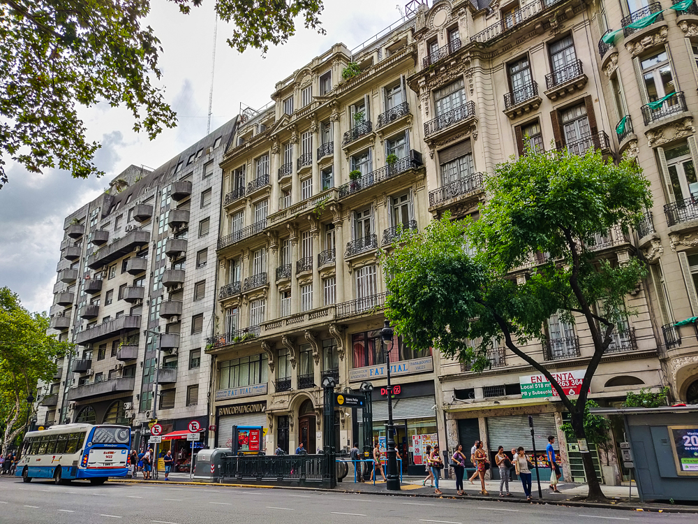
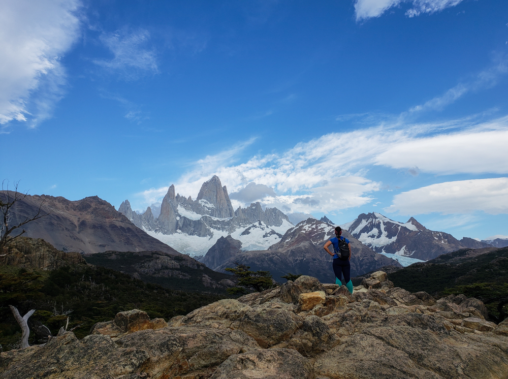
Instead of spending another day aimlessly wandering the city, like on our first day in Buenos Aires, we attempted to formulate a plan to make the most of our only full day in the city. The ongoing Lara-and-Mike travel struggle is that, outside of hiking, we have completely different interests. Mike doesn’t understand the point of visiting cities because “What do you do on vacation in a city?” Um… More like WHAT DO I DO WITH THIS QUESTION, MIKE? You go to museums and look at the buildings and walk around and eat ice cream and experience the culture… but the only thing on that list that Mike’s mildly interested in is ice cream (though he’ll say he doesn’t really eat sweets. Get outta here with that), so I’m not quite sure what to do. His input is generally, “I don’t care,” which is not helpful. I try to end up with an itinerary of a few things I hope he won’t totally hate, plus a few that he will but, oh well, because I really want to do them.

We planned to go on an 11AM tour of Recoleta Cemetery and built the rest of our plans around that, picking out some stops to make along the walk there. First, we went to the national theater, Teatro Colón, to get tour tickets for later in the day (a “Lara really wants to do this” activity, in case you couldn’t guess). From there, we did a walk-by of El Palacio de Aguas Corrientes (literally “The Palace of Running Water”) because I read somewhere that it was architecturally interesting. Well, it’s definitely that! I’m mostly confused by it because functionally, it seems like it should be a bland building… like it was built in the late 1800s to be a water-pumping station, bringing running water to the city. Why on earth did they spend the money to import 300,000 glazed tiles and enameled bricks from England and slate for the roof from France, on top of all the cast iron for the structure from Belgium? (Can you say, “World’s Most Beautiful Water-Pumping Station”? I bet this building would win… How much competition could there be in that category?)

The epic Palace of Running Water.
If you were just walking past this on the street, what would you think was inside? Without the benefit of x-ray vision, I can’t imagine that your answer would be “ginormous water tanks and pumping equipment”.

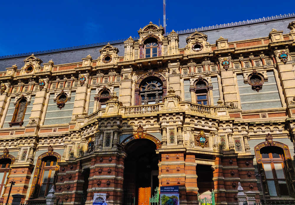
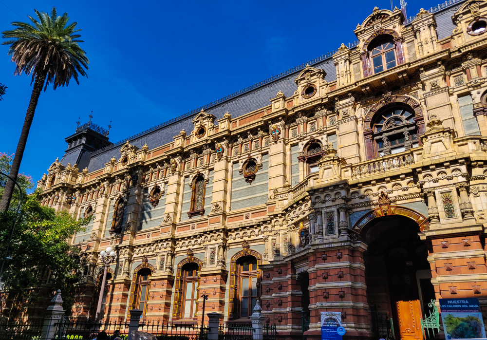
Today, it still is used as an administrative building for the water company, and there’s a museum inside which is the definition of offbeat… The Museum of Water and Sanitary History, featuring (according to their website) pipes, meters, faucets, and “sanitary artifacts” like toilets and bidets. I’m confused by its existence, honestly. But I will say this, if I’m ever back in Buenos Aires, especially without Mike in tow (quirky isn’t really his style), I will absolutely be checking it out.

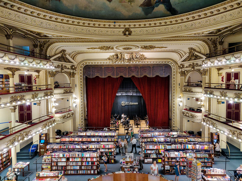
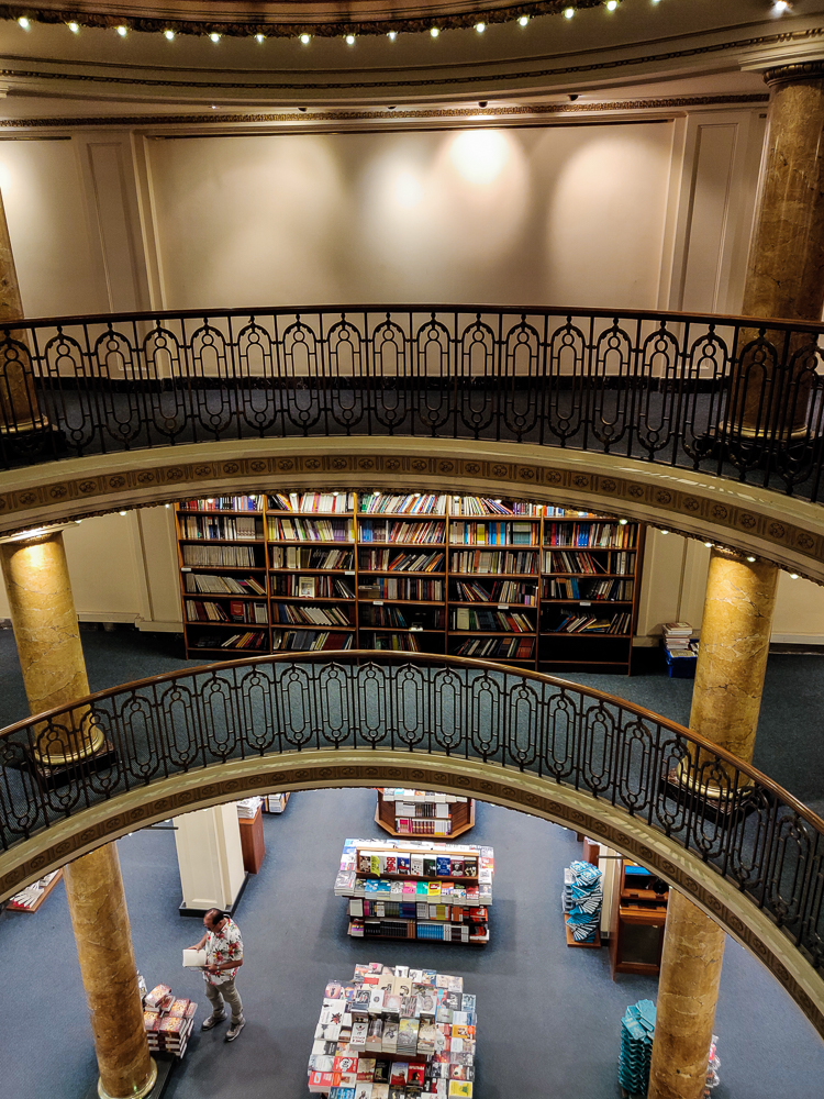
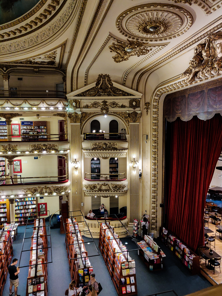
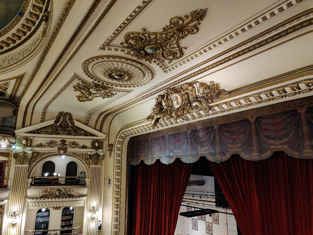
After taking a lap around the building (a lengthy endeavor, considering it occupies an entire city block), we made our way to El Ateneo Grand Splendid, a bookstore a few blocks away. It’s in an old theater and is, of course, the world’s most beautiful bookstore. Unlike the water-pumping station title which I just made up, this is something that people actually do say. I don’t know who gets to be the authority on these claims, but it’s undeniable… “most” or not, it is very beautiful. I’m biased, though, because books and theaters are two of my favorite things, so combining them is a surefire way to win me over.

The building dates back to 1919, originally built as El Teatro Grand Splendid. In its heyday, it hosted performances by the tango greats (another thing for which Argentina is famous) until becoming a movie theater in 1929, one of the first in the city. It didn’t take its current form until 2000 when, in danger of demolition, it was rescued and converted into a bookstore.

Tell me this isn’t the stuff of dreams.

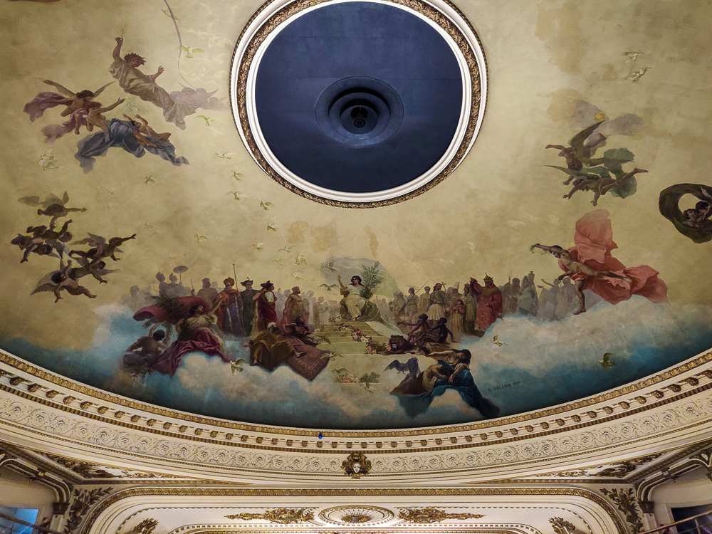
Except for the seating areas, I imagine that the building looks pretty much as it did in its theater days. The stage is a café. The seating areas have been taken over by bookshelves. There are wrought iron balustrades and gilded balconies. A massive fresco dominates the ceiling. One of the boxes by the stage is a reading nook. It’s a dream.

I don’t know why every bookstore isn’t in a theater. And every library. And really just everything.
“How many times can you take essentially the same picture?” Well, you’re about to find out. And these are just the ones that I couldn’t choose between!
My best attempt at getting a picture of the whole ceiling. It was impossible.
Hmm… I wonder if they’re hiring? I wouldn’t mind working here every day! Wait for meee! I’ll be back just as soon as I can get into the country!
Okay, I have no idea what kind of disaster is happening across the way with the lighting on that wall, but ignore that and focus on the balustrades (the fabulousness underneath the railings). (Hire me and I’ll fix your lighting!)
The bottom box is a reading nook/my future tiny house.
Really I’m just happy that the space was successfully repurposed because what a shame it would have been for this theater to be torn down and lost forever.

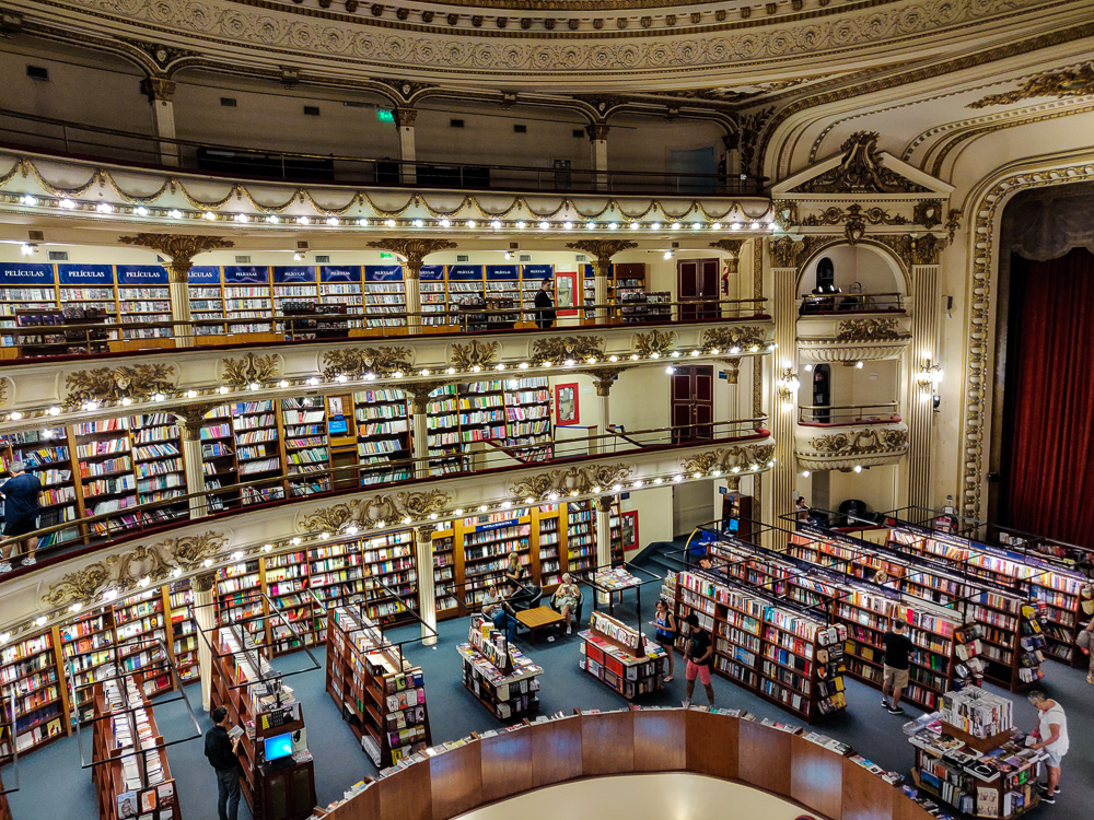
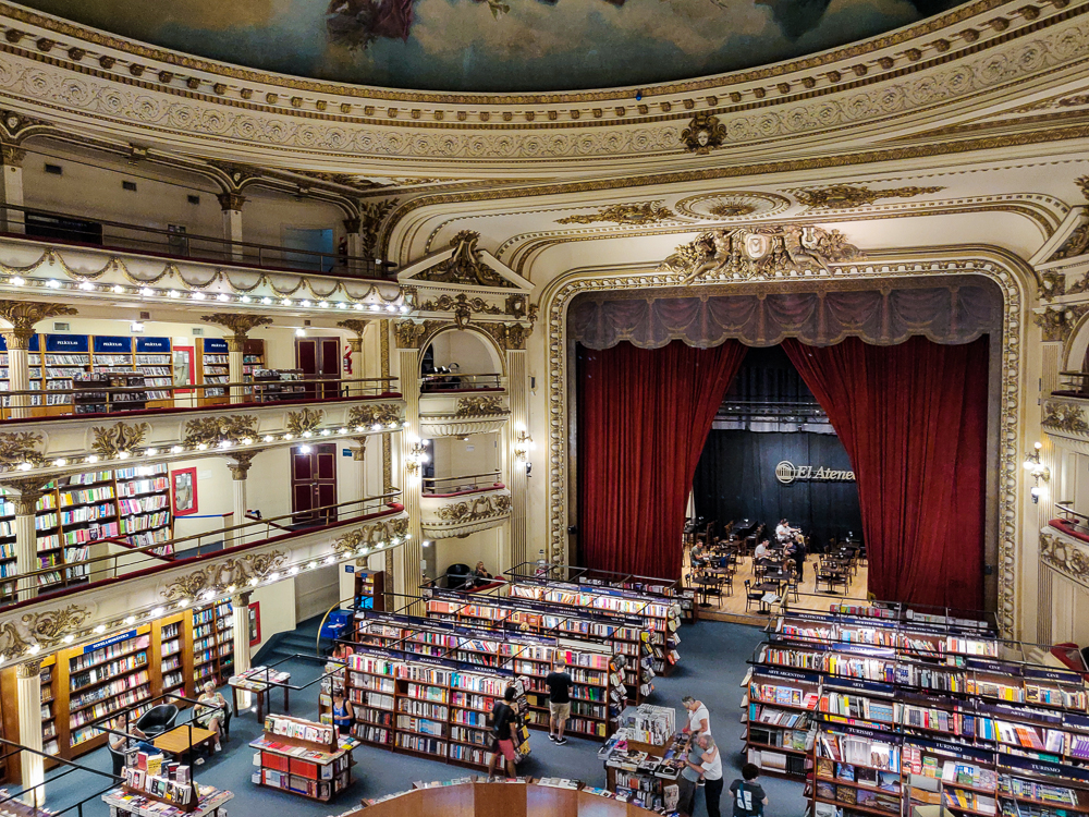
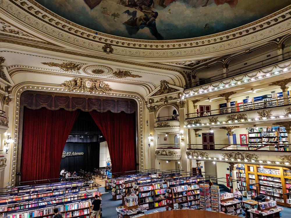
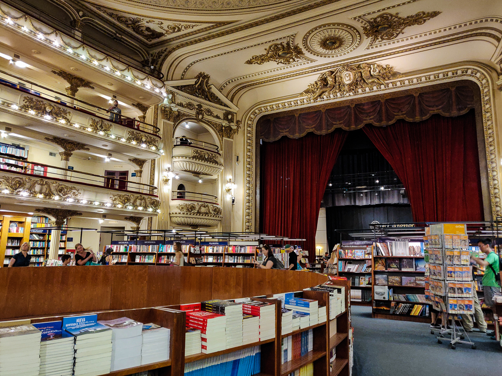
I hoped that it would be cool enough for Mike to enjoy even without a love of books or theaters, and I think it was! Maybe it was just the air conditioning that won him over, but hey, I’ll take it. We spent at least half an hour there, wandering around to soak in the general splendor and check out the books. I could have stayed all day (or forever), but alas, the cemetery awaited, so we headed back onto the sauna streets.

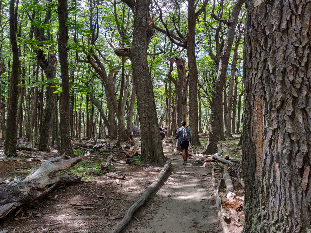
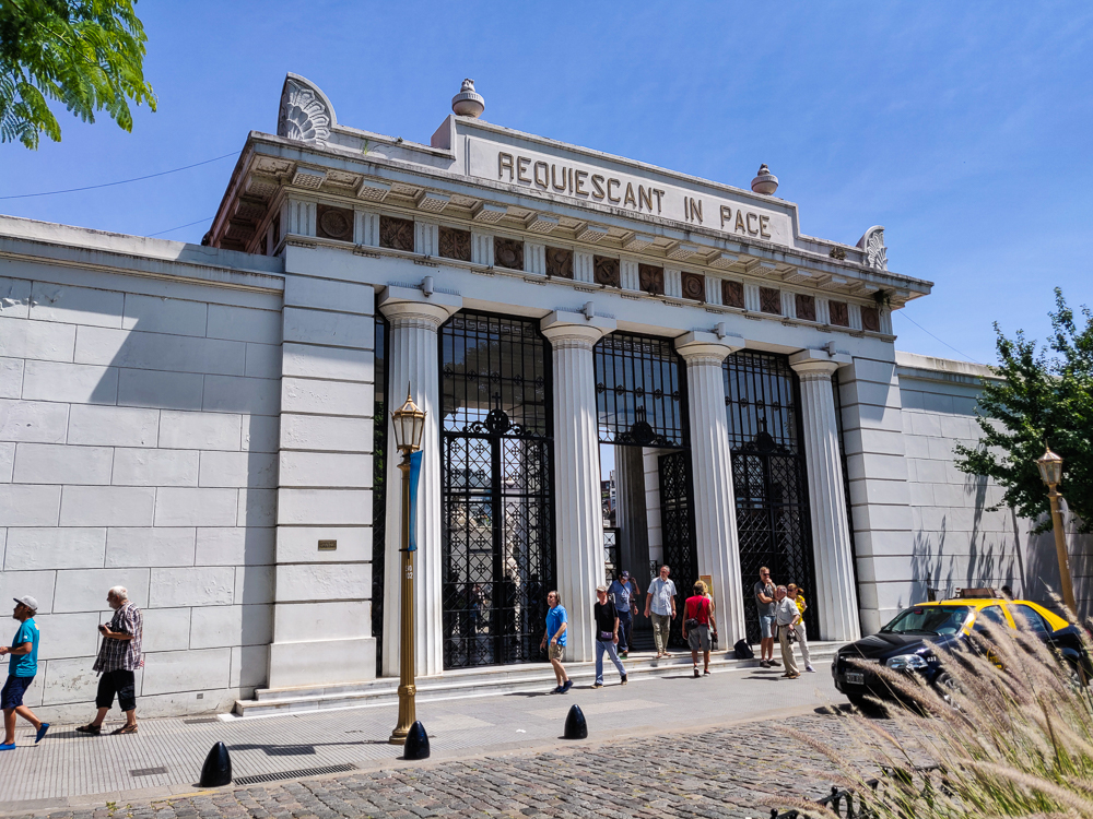
The cemetery has free daily tours… in Spanish. Why not, right? Get a little language practice, maybe learn a few things. Well, it was a nice thought, but the only thing we learned was that we were NOT up to the challenge. I caught maybe 40% of what the guide was saying, between the cemetery vocab that I lacked (all of it), the speech rate (rapid), and the castellano accent (strong). My gosh. My Spanish brain maxed out after maybe 20 minutes, and Mike was on the same page. We ditched the group and wandered around on our own.

The entryway to Recoleta Cemetery
Exploring

This is where I discovered that Mike doesn’t have the same appreciation for cemeteries that I do (I love them, in a completely normal/not creepy/not weird or worrisome way). You’re shocked, I’m sure. He lasted maybe five minutes after we left the tour before saying, “Whenever you’re ready to go, I’m ready.” I know he wasn’t trying to put pressure on me, but geez. I thought it was fabulous.

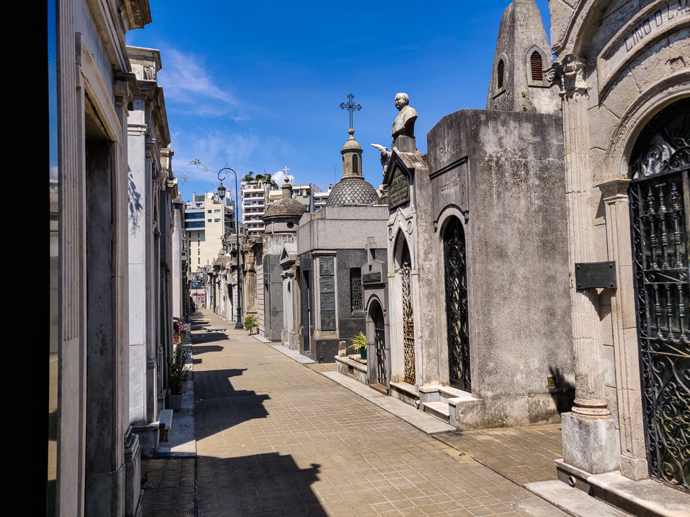
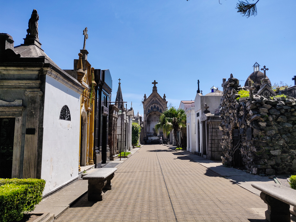
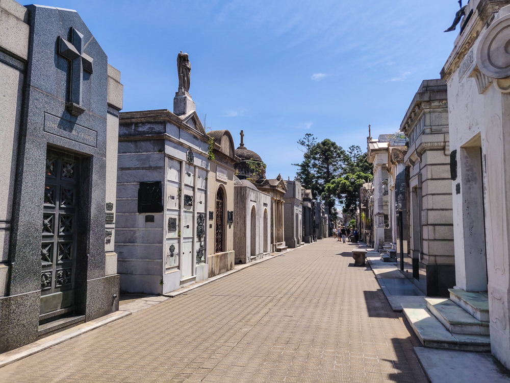
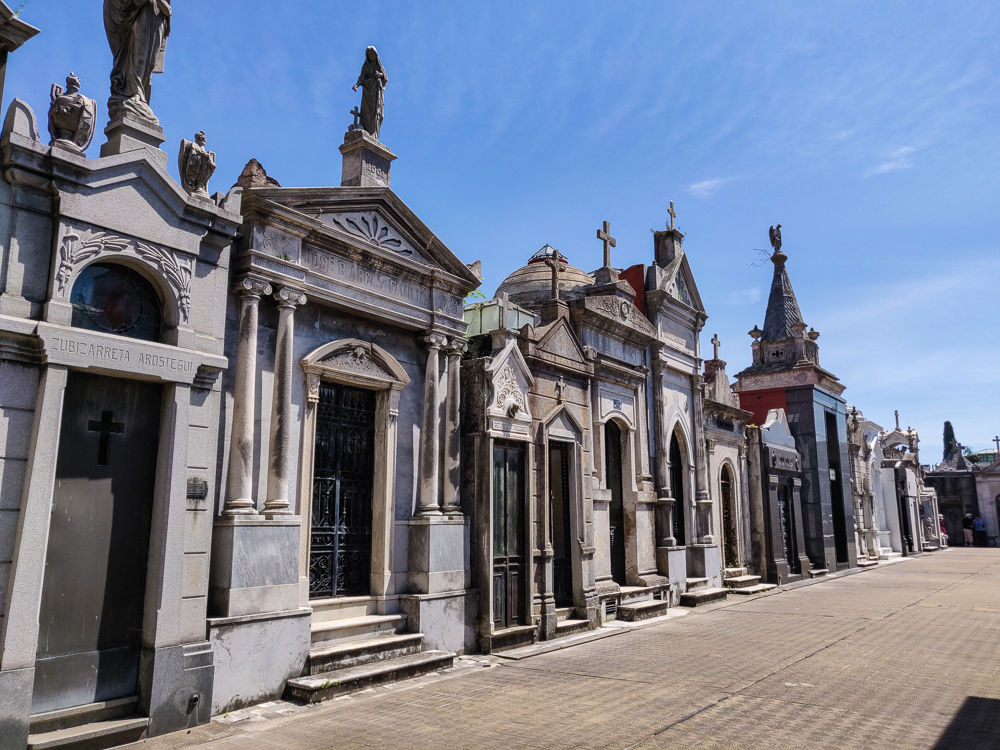
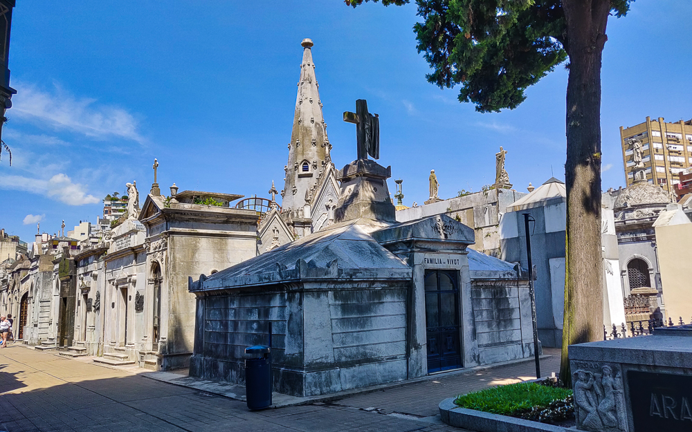
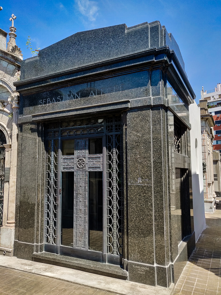
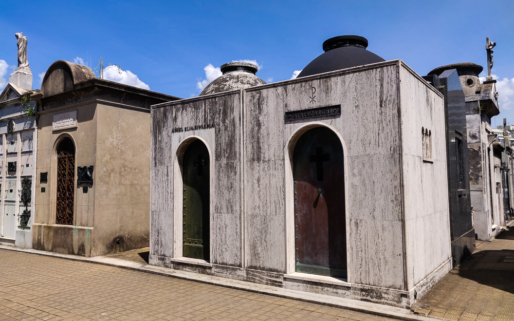
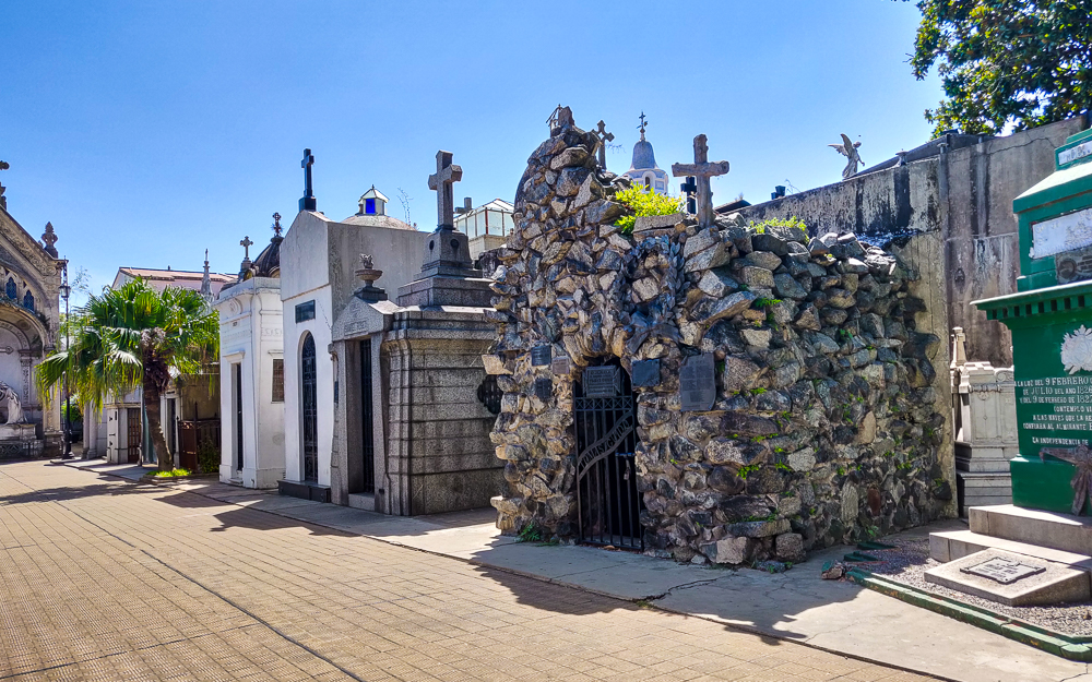
Recoleta Cemetery is one of those sites that everyone says is a “must visit” in Buenos Aires. Established in 1822, it was the first public cemetery in the city, and it’s THE place to be buried if you’re rich and/or important. It’s like a small city, stretching across 14 acres with more than 4600 vaults. It’s a good thing that they took the time to design a layout because without the predictable grid of walkways, it would be all too easy to get lost inside. (As much as I like cemeteries, I am not interested in that. Noo thank you.)

It’s like a city with lots of very small houses.
All of the “streets” aren’t this wide. This is basically a boulevard in the cemetery world. The majority were narrow enough that I could touch both sides by sticking my arms out.

It’s been ranked as one of the world’s most beautiful cemeteries, and while I’m not looking to dispute that, I do think it’s a weird thing to rank. Also, how many cemeteries did the authors of these articles visit before deciding? What were the evaluation criteria? I mean, it is quite nice. But like… what?

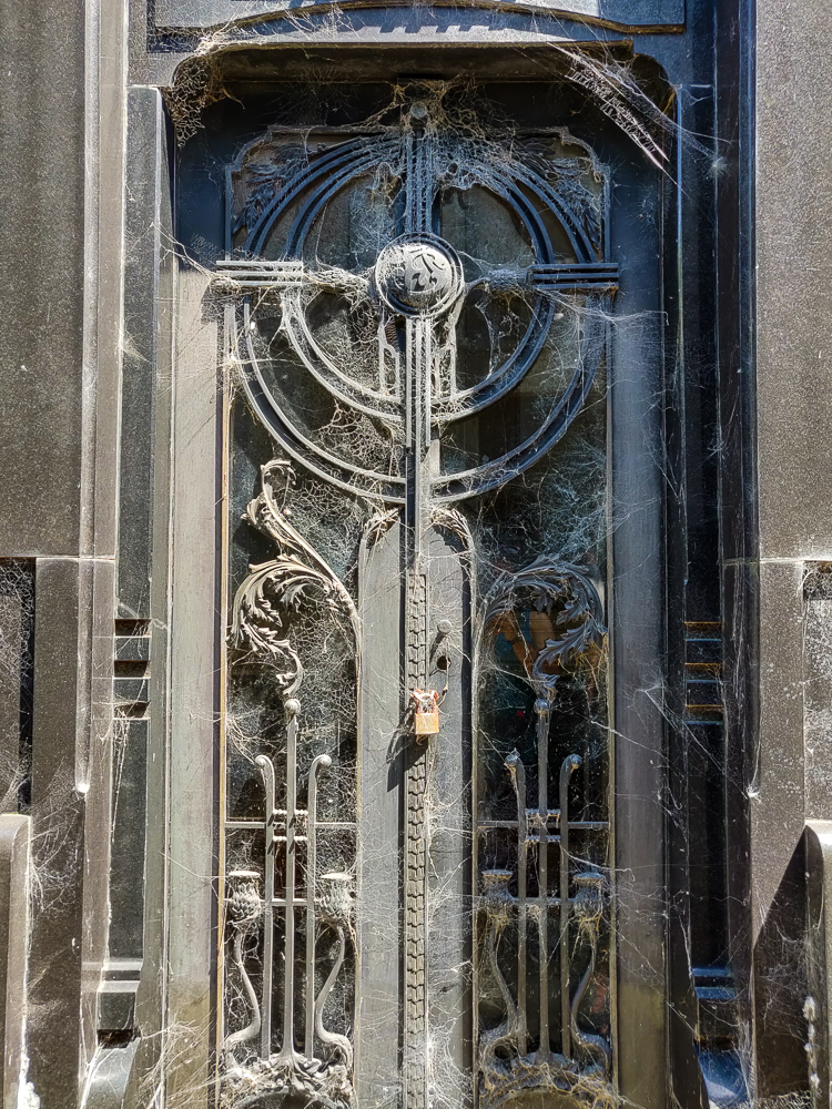
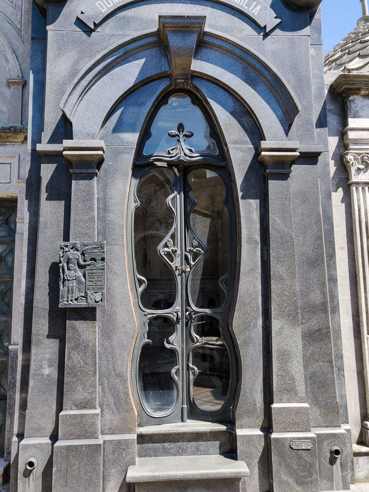
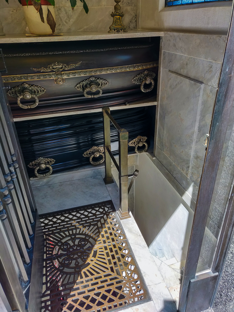
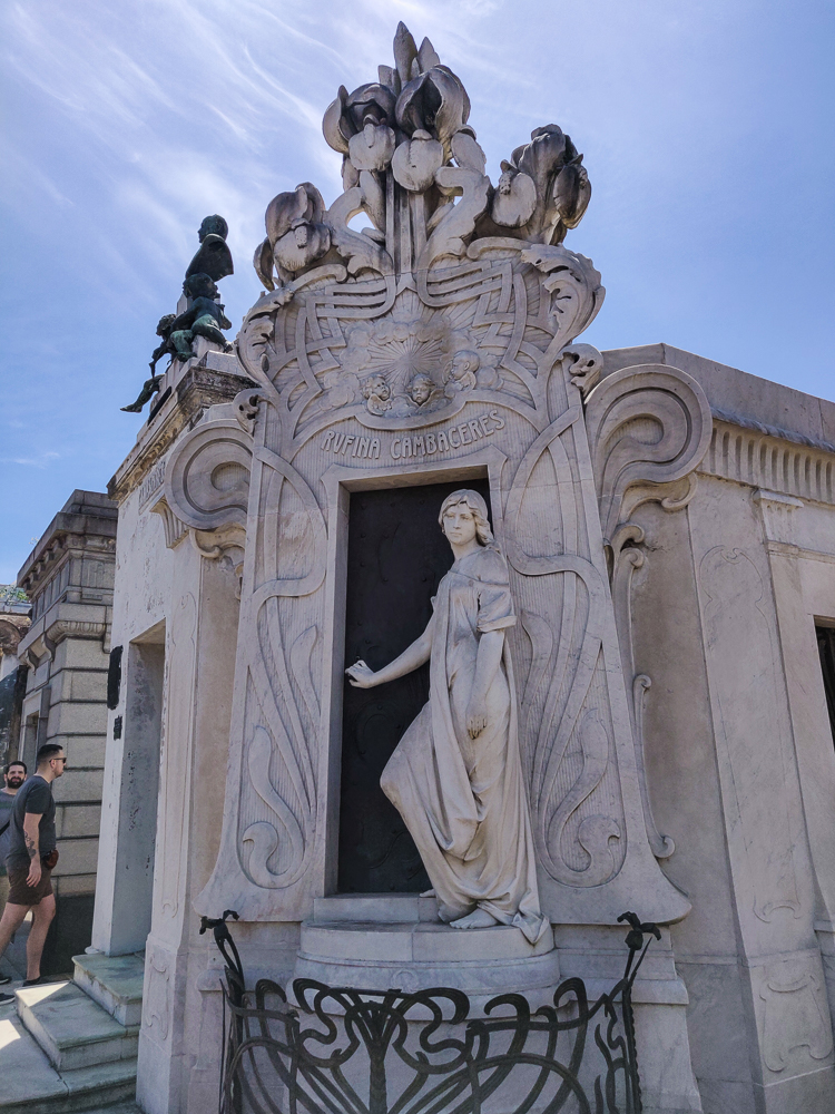
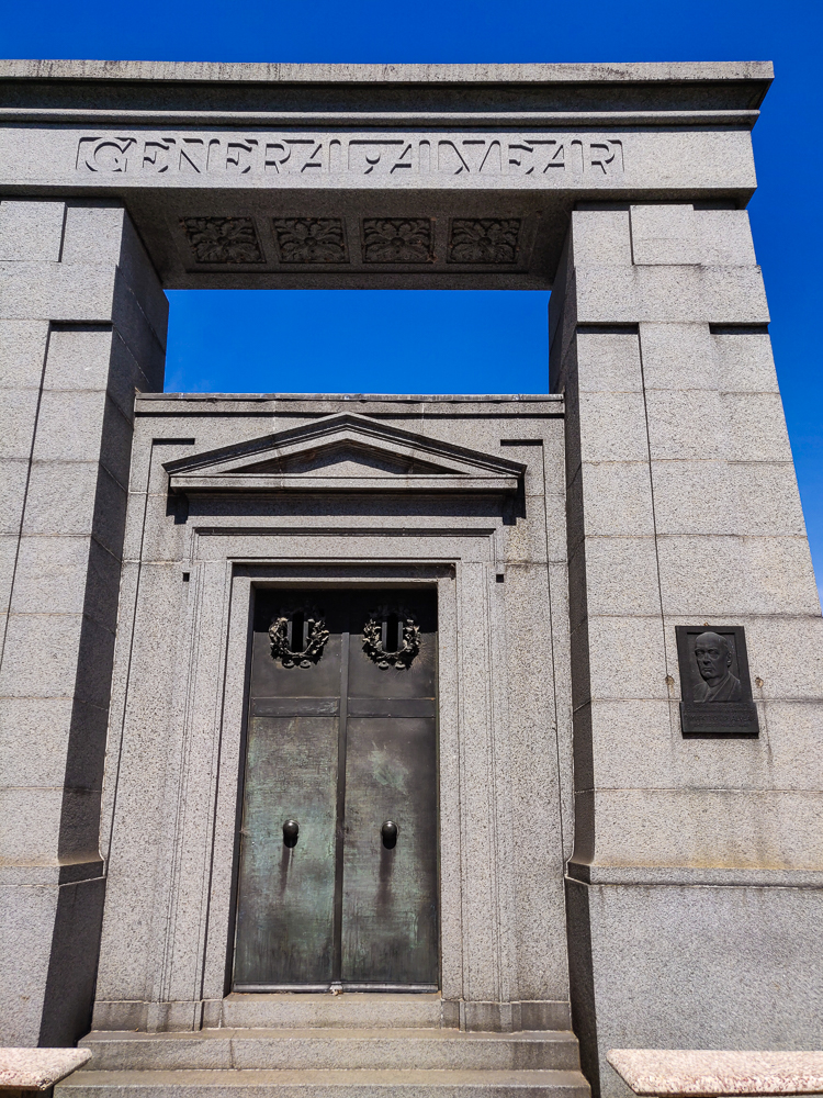
The mausoleums are the definition of extravagant. It’s a little strange, actually. A lot of them have windows, so you can see what’s going on inside. Above ground, there are usually one or two caskets and then some skinny minnie staircase leading underground to what I assume is more casket space? And architecturally, they each have their own personality. I felt like I was walking around an architectural style sampler… a little baroque here, some art deco there, classical and neo-gothic sprinkled about.

Because why not build a mausoleum modeled after a Roman temple?
This guy is missing part of an arm, but that’s a case of neglect (the family moved to another cemetery. What a weird concept haha) rather than the original design intent.
I just love the variety!
I’m always a fan of a good mosaic.
THOSE SPIDERWEBS. Seriously, so artfully placed.
Some are like rowhomes, one on top of the next… and some are like this little freestanding mausoleum-hut. Not my favorite design, but it sure knows how to take up space.
This one seems very… secure. Like a bank vault.
And then there’s this one, open and airy and the complete opposite of the bank vault.
This might be my favorite one. The doors!
This one just happened to be open, so I obviously stuck my head inside to get a better look at the layout… The mausoleums are of all different sizes, but this is what the majority look like inside, more or less.
I don’t know what’s going on with these, style-wise, but they’re definitely unique.
Hotel lobby?
This was just me doing my Armenian duty by seeing an Armenian name and taking a picture because I’m sure we’re basically cousins if you go back far enough.

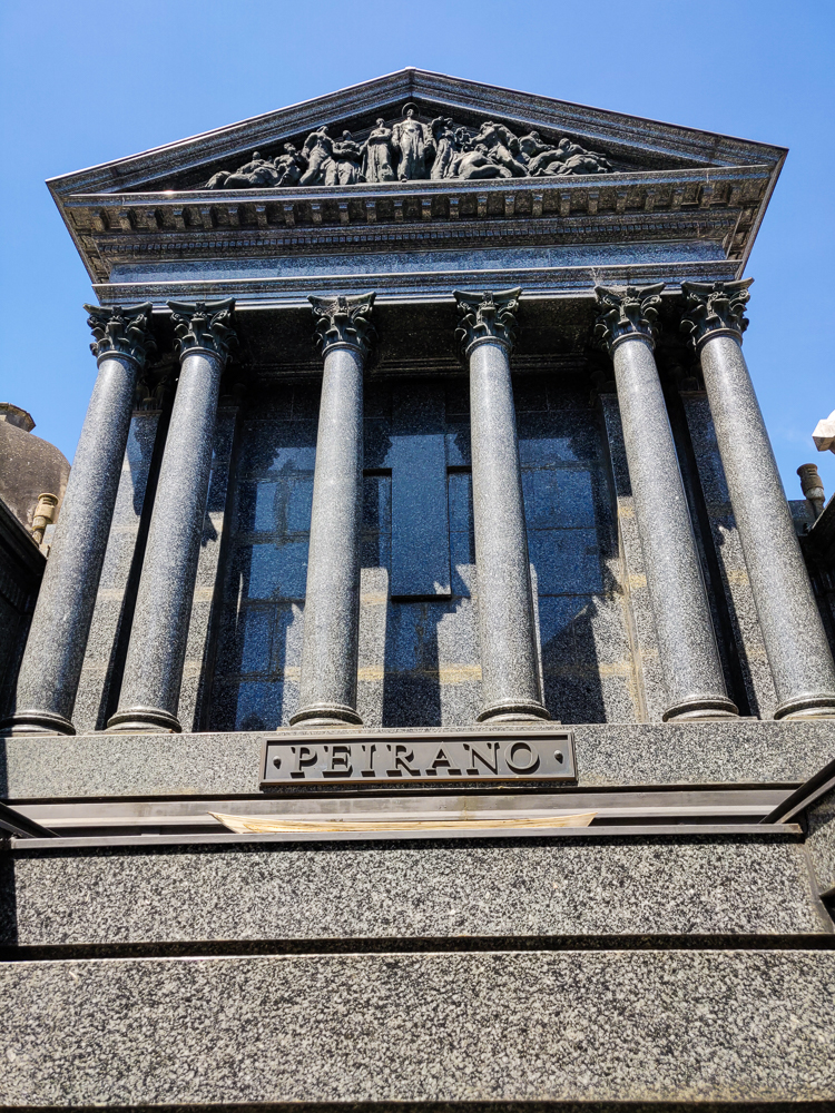
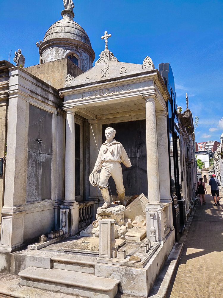
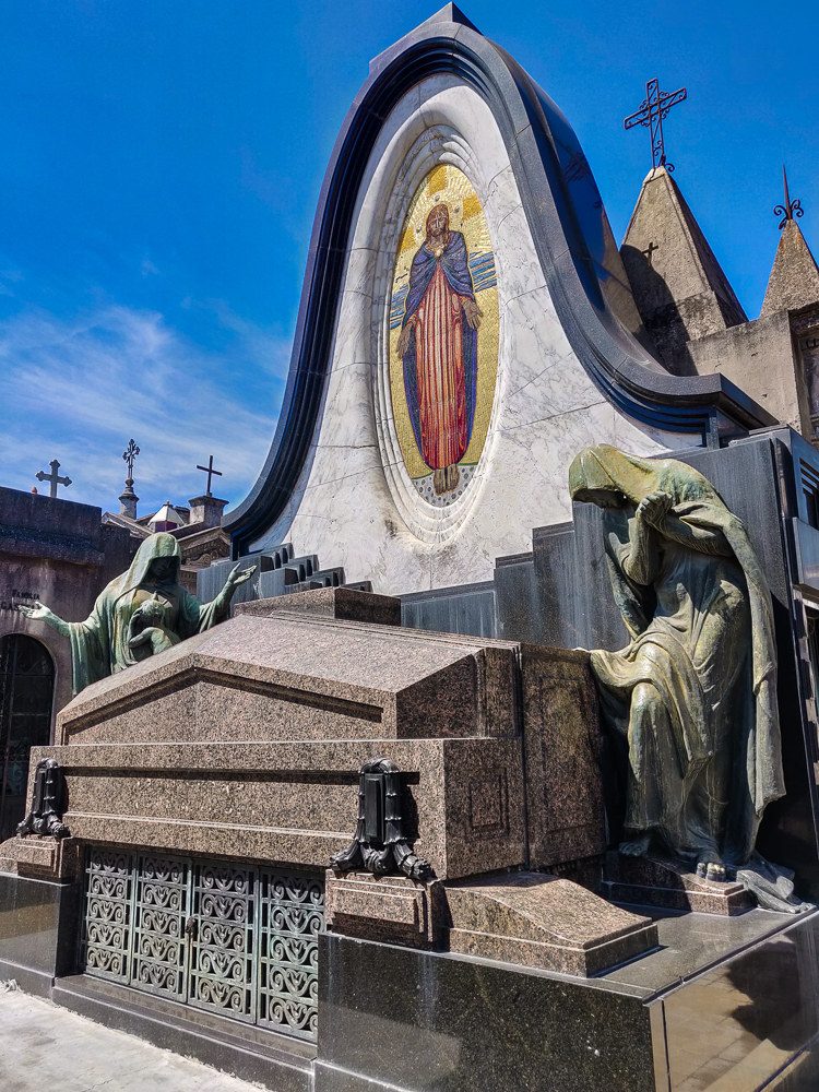
Even though we skipped out on the tour, I thankfully had done a little reading ahead of time and knew a few of the “famous” mausoleums to look out for.

The legend surrounding this mausoleum is the stuff of nightmares. Rufina Cambacérès was 19 when she died suddenly, of a heart attack. She was buried, and cemetery workers heard strange noises coming from the mausoleum. When they opened it up, they found that the coffin had shifted. Rufina’s body was still there… but the inside of the coffin was covered in scratch marks. She had been buried alive and tried to in vain to escape. True or not, just the thought is enough to make you squirm.
The “General Alvear” referred to at the top was a general during the War of Independence. This massive mausoleum (prominently located just inside the entrance to Recoleta) is also the final resting place of his son, a mayor of Buenos Aires, and his grandson, a president. Bunch of underachievers.
This was built for Tomás Guido, a general in the War of Independence. He helped to liberate Chile and Peru from Spanish rule as well, crossing the Andes with his troops. His wish was to be buried underneath the mountains they crossed, so his son had stones brought from there to Buenos Aires and built this mausoleum himself for his father.

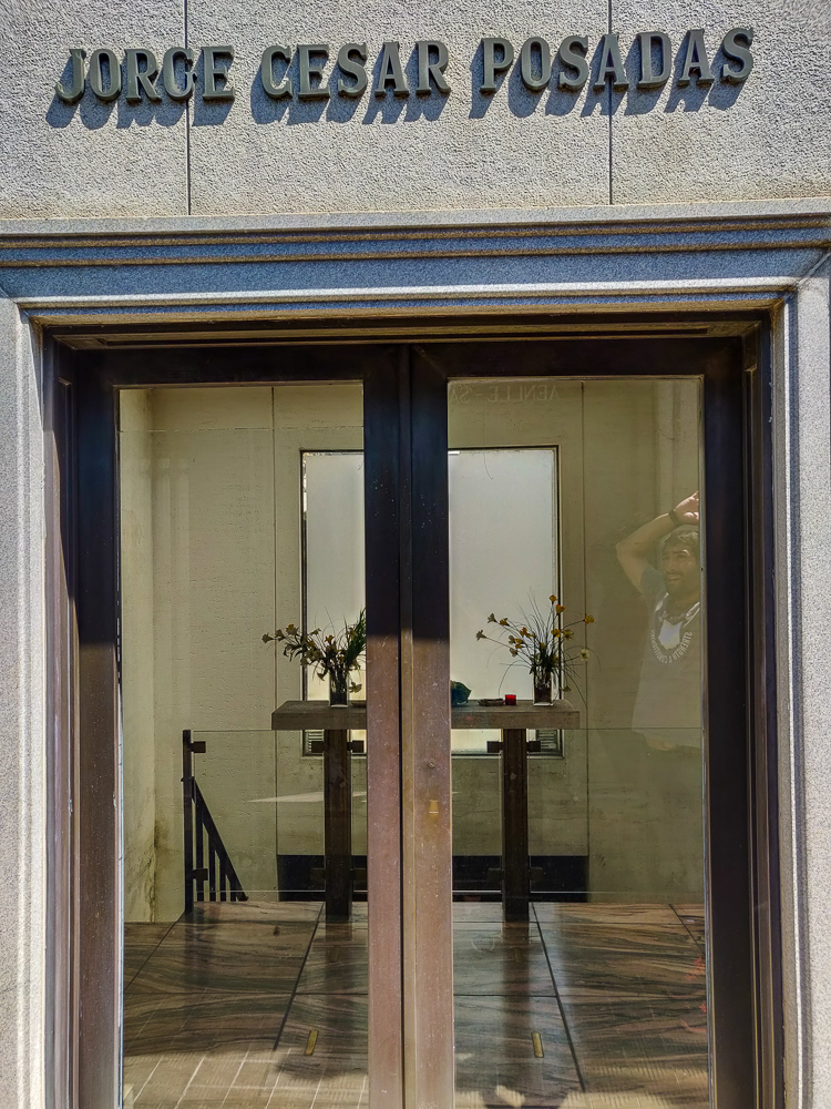
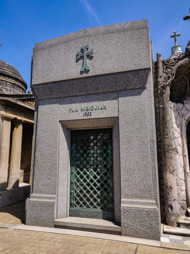
We wandered long enough to see most of the graves I was looking for and to admire the general award-winning beauty and then called it a day right around when we found the Armenian mausoleum. It seemed like a fitting way to end our time there. Plus, we had a tour to catch at Teatro Colón, and I didn’t want to risk being late! Coming up next time, get ready for some fab stained glass!

Since it’s been a while since my last post about Mike’s and my trip to Patagonia/Buenos Aires, let me reacclimate you. We just finished 7 days of hiking, hiking, and hiking, and by some miracle, my feet didn’t fall off (though I did end up losing a few toenails. I’ll spare you the pics but send me a message if you’re interested. Kidding. Kind of. I mean, I do have pictures, and you’re welcome to them if that’s something you’re into. Okay, I’m getting carried away. Back to it).

From El Calafate, we had a bright and early flight to Buenos Aires where we were staying for a couple of days before heading home. We flew into the domestic airport which is conveniently located in the city and then went on a public transit adventure… my favorite. And, a perfect place to start off a list of Buenos Aires first impressions! (Or, you can catch up on the history of Argentina first, HERE and HERE.)

1. Heat/Humidity – Okay, so this has nothing to do with public transit, but I feel like it needs to come first because this was truly my very first impression of the city. When Mike and I flew to Patagonia, we had to change planes in Buenos Aires and walk outside to switch terminals. It was the middle of the night, and the air felt like stepping into a bathroom after someone takes an hour-long, steaming-hot shower. With no ventilation. I have certainly experienced plenty of humidity in my life, but usually the night feels slightly less suffocating! NOPE. I was thankful that, from there, we flew south to cooler temperatures, but that was just delaying the inevitable. This time, we arrived in the morning, and between the humidity and the brutal sun, I was ready to get right back onto the plane.

Not a cloud in the sky! Usually this is considered a good thing, but my gosh what I would have paid for a few clouds riiight in front of the sun…

2. Public Transportation – It’s quick. It’s easy. It’s cheap. You can get practically anywhere in the city. Fresh off the plane, we set out to buy ourselves a transit card (I’m developing quite the collection of these) which was fairly straightforward except that you can’t buy the card and add money to it at the same place because that would be too easy. But, at least you were able to do both of those things at the airport! (If that sounds like it should be a given, trust me when I say it’s not.)

We also used the subway later in the day, and I’m a big fan. Partly because I was exhausted and it saved me from 40+ more minutes of walking… but also because it’s great! The line we took was clean and not shady and impressively prompt. Also, fun fact: the Buenos Aires subway was the first in South America! It was built in 1913 which, as you may recall, was during Argentina’s golden age.

If you need a Buenos Aires transit card, I’m your girl.

3. Bus Lines – I don’t mean bus routes. I mean lines of people WAITING for buses. I’ve never seen anything like this. At rush hour, the sidewalks are full of people lined up like they’re waiting for the latest iPhone. Kidding, there are no tents… but there are seemingly endless lines of people, and they’re just doing their regular commute, waiting for the bus. It’s crazy! And also nice in a way because people aren’t trying to edge you out to get on the bus before you. But, you need to know what you’re doing and start moving as soon as the right bus pulls up because people operate like a well-oiled machine. There’s no time for hesitation.

Also, bus drivers seem to always be in a rush, so be READY when it’s time for your stop. As in, be standing at the door, and start hopping off as soon as the bus slows and the door opens because a “slow”, rather than a stop, might be all you’re getting.

I know you’ve seen this picture before, but it’s the only one I have that even kind of shows the crazy width of the road. Since the obelisk is here, the big medians I mentioned have been replaced by the obelisk island. But, those buildings alllll the way across show where the street finally ends (and it doesn’t get wider here because of the obelisk… it’s this wide everywhere).

4. Avenida 9 de Julio – This is the major north/south boulevard in town, and I don’t even know how to begin explaining this street to you. Mike and I got to enjoy its dedicated bus lanes on the ride to our hostel. Not having to share space with the other traffic probably cut our travel time nearly in half.

How do they have space for these dedicated bus lanes? WELL. It’s the widest avenue in the world, and for maybe the first time after hearing a “most/best/biggest/etc. ___ in the world” claim, I immediately believed it. It’s literally an entire city block wide. Like if you built a city on a grid and then removed the buildings between two of the streets and paved the whole thing, this avenue would be the result. There were something like 16 lanes before the middle was blocked off for buses in 2013. (This is one of those times when I really wish I had thought to take a good picture, but alas, I’ve failed you all. I’m sorry. You can google it, though.)

Crossing it is no simple task and takes far too long. There are multiple traffic lights along the way and no chance of getting across on a single green. First, you cross three lanes of traffic. Then, there’s a “median” with a width equivalent to maybe seven lanes. Next, you cross six lanes, a small divider separating the bus lanes, and two dedicated bus lanes. Okay, now you’re in the middle of the street/where you need to be in order to get on a bus. But, if you’re just trying to get across, you still have two bus lanes, four lanes of traffic, another large median, and three more lanes of traffic before you’re safely to the other side. It’s at least as exhausting as it sounds, plus there’s not much shade which means you’re simultaneously getting fried by the sun. We avoided crossing whenever possible.

5. Drivers – In classic South American fashion, the roads are terrifying, and you couldn’t pay me enough to drive on them. Everyone drives like they’re in a massive hurry (which is funny because probably no one actually is… the pace of life is SLOOOOW), the road rules are mere suggestions, and the lines on the road are for decoration. Defensive street-crossing is required as a pedestrian unless you have a death wish (aka don’t assume that anyone is going to stop for you, even if you have right of way).

6. Money/ATMs – After we made it to our hostel/took some time to chill (literally… I felt like I was going to pass out), we headed back out to find somewhere to exchange money. This turned out to be a much more challenging task than expected. Normally, I would just use an ATM to get local currency, but the fees in Argentina were the highest I’ve ever experienced. For a single withdrawal, the fee was at least $10! (For reference, many ATMs will charge you nothing, or fees are usually in the $1-3 range.) My US bank reimburses ATM fees to a point, but we figured we’d just exchange money because I had some cash and we didn’t need much, making the high fee seem even more ridiculous.

WELL, that was a mess, too! I mean, there are plenty of shady dudes on the street yelling, “CAMBIO! CAMBIOCAMBIOCAMBIO!” (exchange) but forgive me if I didn’t have much confidence in their legitimacy. All of the legit exchange places would only change more than US$100, and we didn’t need even close to that for our last couple of days in the country. So, after all that, we ended up exhausted and frustrated… and getting money from an ATM (after googling to find out who had the least-unreasonable fees. Side note, the best ATM we found in Argentina was, shockingly, in the main airport. It had the lowest fees and the highest allowable withdrawal amount. Go figure).

Mike and I took a break from our exchange adventure to get some ice cream. This heaping cone gets all the credit for carrying me through the day.
That’s Eva Perón, former first lady of Argentina.
Can someone please explain to me why every other country in the world has prettier money than the US?

7. Exchange Rate – Besides the complexity of simply getting money, there’s the added confusion of the constantly-fluctuating exchange rate. When I was doing research and trying to figure out how much things cost, every piece of information I found seemed to be conflicting… unless the price was listed in USD. Since the value of Argentina’s currency is so unstable, many tourist attractions simply list prices in US dollars so that they don’t have to keep changing them.

8. “The Paris of South America” – NO, NO, NO. This is just the kind of ridiculous claim that I despise and immediately dismiss. While I refuse to accept this as an even remotely valid comparison, I will say that the architecture of the city has a very European vibe to it, more than Lima and Quito (the only other South American capitals I have personal experience with). If wrought-iron balconies and café culture were all there is to Paris, then sure. However, you could absolutely NOT go to Buenos Aires and then be like, “Well, guess I don’t need to go to Paris anymore because I’ve basically already been there!” NO.

Welcome to Paris!
Those balconies are fab, but get that glass monstrosity outta here. Paris of the South? Psh!

9. Accents – Every Spanish-speaking country has its own dialect and accent (just like US vs. British vs. Australian English), but Argentina takes it to another level. It’s like Spanish with an Italian accent and then some random Italian words sprinkled in for good measure. They refer to Argentinian Spanish there as “castellano”, and instead of saying that “cas-teh-yano” like you would in normal Spanish, you say “cas-teh-shano”. The “y” and double-L (usually pronounced “y”) take on more of a “sh” or soft “g” (like in “mirage”) sound. There are plenty more differences, but I’ll leave you with just that. We had no problem with people not understanding us, but my gosh it was hard to get used to understanding them!

10. Argentinian BBQ – You can’t go to Argentina without eating Argentinian barbecue (so I’ve been told). After primarily subsisting on ravioli, protein bars, and dried Ramen noodles (okay, that one was just me) during our time in Patagonia, Mike was VERY excited about this. On our first night in the city, we went to a place recommended by the receptionist at the hostel. I put him in charge of ordering since his excitement level far outweighed mine, and so, we split pork chops, a steak, and a plate of crispy waffle fries. What a balanced meal, right? A more thorough commitment to the cultural experience of barbecue would have included some intestines, but for some reason, he decided to skip those.

Mike raved about how inexpensive it was, while my eyes bugged out at the prices when I opened the menu. This is the difference between someone used to NYC restaurant prices and someone used to eating 50-cent-a-bag pasta in a hostel kitchen. (In this case, I’m sure Mike was right, that it was inexpensive for what we got. I’ve also never ordered a steak in a restaurant before, so I had no reasonable reference point.)

They’re not messing around. At the top, it says, “A burning stove is the heart of Buenos Aires.”
Protein, anyone?
There’s actually nothing better than waffle fries. Between these and the ice cream, this was really an ideal Lara food day.

After our protein- and carb-laden dinner, we jetted back to the hostel, courtesy of the subway system, and totally crashed (us, not the subway). Whew! Heat and humidity really take it out of you! Thankfully, we had a functional air conditioner in our room, saving us from the choice between a million mosquito bites from keeping our windows open or potentially dying of heatstroke from keeping them closed. Talk about luxury living!

Our only full day in El Chaltén was dedicated to the hike to Laguna de los Tres. It’s the most popular hike in the area, is listed as “difficult”, and is supposed to take 8 hours, so we were prepared for all of the above. In our usual “let’s avoid the crowds” fashion, we aimed for an unrealistic early departure time (6:30AM) and left at a more reasonable early departure time (7AM) which is apparently still long before anyone else in town is even awake. Well, except for this one guy we met who said he hiked there for the sunrise, but he was a rare bird (we’ve been over this before, but who wants to hike for 4 HOURS in the dark??). Anyway, we were not in good company at 7AM. We were in nearly no company. Fine with me!

The valley on our way up
Sleepy valley

The general profile of the Laguna de los Tres hike felt pretty similar to Laguna Torre, the hike we did the day before, but slightly “more”. The beginning has a bunch of unshaded uphill with great views of the valley. When you feel like you might collapse, it turns flat, and trees start popping up!

The shadeless beginning of the trail
No. Shade. Also, see the little rock peeking up in the far background? That’s where we’re headed (though I didn’t know it at the time).
Slightly sunnier view of the valley
The world slowly waking up
Gnarled forest along the way
Funky forest

About an hour in, the trail forks, and we picked the path that goes to a viewpoint where we got our first glimpse of the mountains we were headed towards. It was breathtaking! And we were super lucky with the weather again, so the skies were clear and the views were completely unobstructed. Seeing the mountains was good motivation to keep going but was also like… “Wait, we’re walking ALL THE WAY THERE??”

Me gazing at Fitz Roy from the viewpoint
First look at the mountains. Can you say WOW!?
Mike with Fitz Roy
This is where I start having the same-ish pictures over and over again because they’re all so darn beautiful.
Selfie with Fitz Roy
Brother-sister selfie!
Fitz Roy and the rest of the mountains
Okay one more. Fitz Roy is the tallest peak in the middle, to the left is Poincenot, and to the right is Mermez.

From the viewpoint until the very last segment of the hike, the trail wasn’t bad at all. It’s basically flat… and then you get to the end, and there’s a sign that says the last kilometer is going to take an hour because it’s like 400m of elevation. And then it actually takes an hour. And it is SO steep. And long. And steep. It wasn’t the worst hike I’ve ever done, but it wasn’t exactly a walk in the park either (lol but technically it was a walk in the national park).

Fitz Roy with some cloud cover
Stay away, clouds!
Fitz Roy with some clouds trailing off the peak
It’s like a little smokestack. Getting closer…

The good news was that we were there early, so there weren’t a lot of people coming down. That part of the trail is only really wide enough for one person at a time, and it would have made things much worse if we had to keep moving aside to let people pass. And, probably most importantly, the sun still wasn’t too hot because of course there was zero shade from that point on.

The one thing that was far from ideal was the wind. It was crazy! Most of the way was shielded from by the mountains, but the final stretch was completely exposed. I know I’ve said this before, but I meant it then and I mean it now… I was not confident that I was safe from blowing away. At the very least, there was a very real possibility of blowing over, and it was so steep that blowing over would probably also mean rolling down the mountain. I stopped multiple times and just dug in because I wasn’t confident that I could land my foot where I wanted.

Green valley
100% chance that I took this picture as an excuse to stop hiking for a second. We came across that river on the left side and through the green patch above it.
Rock and wood-covered trail
The way up…
The rock peaks just over a ridge
Almost there almost there almost there!

Then, I got to the top (Mike was already there), and the struggle was all but forgotten. The mountains you’ve been looking at all day are RIGHT THERE, with their jagged peaks and snowy slopes. The lake below them is the bluest blue you’ve ever seen. (After the brownish Laguna Torre from the day before, it looked especially blue.) There weren’t many people there, and it felt like we were part of an exclusive group lucky enough to experience the magic. Like what the heck is this world we live in??? Who would expect a lake like that, tucked up in the mountains? It’s not even fair for places like that to exist in the world. You blink and blink again and then one more time just to be sure… and it’s still there. And it’s still incredible. And even though it’s clearly real considering you’re standing there looking at it with your own eyes, you think they must be messing with you. How is this place real??? And the weather! I can’t talk enough about the weather. There was one little cloud near the peaks when we first arrived and then it cleared away completely.

Mike and me with the lake
We made it!
Laguna de los Tres
Okay, sorry in advance but like… I took a LOT of pictures, and I only picked a few… But there are still so many because they’re just too pretty! And also basically all the same, but can you blame me?
Me with the lake
Okay now glamour shots
Same pic without me
Okay now get out of the picture, Lara!

We walked down to the lake and then around the edge until we could see another lake right next to Laguna de los Tres, Laguna Sucia. That must be one of those Iceland/Greenland naming things (they named the green land Iceland and the icy land Greenland so that people would leave the green land alone) because “Laguna Sucia” means “dirty lagoon”, and that name couldn’t possibly be less suited.

Me on a rock looking down at Laguna Sucia far below
Laguna Sucia
Laguna Sucia from above
What dirty water, right?

While the two lakes are, basically, right next to each other, it’s super weird because Laguna Sucia is like 100m lower in elevation (that’s a pure Lara estimate though, so take it with a grain of salt because my estimates can absolutely not be trusted). There are waterfalls coming out of the top lake that turn into rivers flowing past the lower lake. So strange.

Laguna Sucia and Laguna de los Tres above
This was my best attempt at getting both lakes in the same picture so that you can see the elevation difference between them. How weird is this??
The blue waters of Laguna Sucia
Someone please explain to me how this lake got the name “dirty lagoon”. The glacier that feeds the lake is at the far end of the picture, Glaciar Rio Blanco (white river).
Laguna Sucia and its awesome surroundings
How is this place real?
Laguna de los Tres and the drop-off to Laguna Sucia
Laguna Sucia is to the left, where it looks like the world just ends.
The waterfall between Laguna de los Tres and Laguna Sucia

We admired the lakes for a while until Mike said he was getting cold from the wind (he was in shorts and a t-shirt. I had long pants and a jacket). Then, we hiked up this little mountain nearby to get one more view of the two lakes before heading back down. Already, we could see that the crowds were getting bigger (aka they actually existed), and clouds were starting to gather around the mountain peaks!

We also eavesdropped on this tour group whose guide was explaining how people rock climb Mount Fitz Roy, the tallest peak. After doing the hike that we just did, they walk around the lake, strap on crampons, and hike up the ice. Probably they will stay the night on the ice, so he pointed out a good place to set up your ice cave for sleeping. The next morning, they walk the rest of the way up the ice, partly having to ice climb until finally there’s just rock. They’ll switch into their rock-climbing shoes from there and take one of the routes that have been defined over the years, basically all named for the origin country/state of the people who first completed it. And after all that, they have to go allll the way back down. Geez. People are crazy!

The water. The mountains. No clouds. HOW did we get so lucky???
The lake. The mountains. Again.
I can’t handle this. Also, that’s the ice patch you have to climb up to get to the peak.
Another lake pic
No words, mostly because I already used them up on the infinity other pictures.
The lake. AGAIN.
THE WATER. I’m still not over it.
The valley
View from the top while trying not to blow away
Laguna de los Tres and a little Mike
Spot the Mike, running away from the wind.
Pano of the lake and surrounding mountains
Pano by Mike from the edge of the lake. AHHH so pretty!!
Me with the lake
This was hurriedly taken in a split-second of calm when the wind stopped blowing because I looked like a marshmallow in the other pics with my shirt all filled with air. Also, look at how the peak is already starting to gather clouds.
Super aqua waters of Laguna de los Tres
LAST ONE I PROMISE.

Mike had big dreams for the rest of our hiking excursion. After we hiked down from the lake, he wanted to explore these two other offshoots of the trail. One was to see another glacier, Piedra Blanca. We walked until we had a good view (we decided there was no need to go all the way to the viewpoint when we could see it just fine already) and then turned around and walked back to the main trail.

Piedra Blanca
The glacier Piedra Blanca is peeking out between the mountains

On that path, there were SO many caterpillars. Earlier in the day and the day before, we noticed that there was a weirdly large quantity of caterpillars on the trail, and we tried to avoid stepping on them. On this trail, there was no avoiding them. It seemed like they might have been an invasive species because there were WAY too many. Besides being all over the path, they were also EVERYWHERE in the branches of the tree and bushes. It got a little creepy once you noticed all of the places where they were lurking.


Trail littered with caterpillars
Spot the caterpillars! (It’s not hard.)
Creepy bush-lurking caterpillars
Me refilling my water bottle from the river
Water break! Drinking from streams never gets less awesome to me.

There was one more offshoot that Mike wanted to check out, and I had decided that I was fine with doing whatever he wanted to do (my feet were feeling surprisingly okay). We got about 6 steps down the path before he decided that the weather seemed questionable, so we should head back. Also fine with me! We still had like 3 hours of hiking ahead. The skies had been getting cloudier and cloudier from the moment we left the lake, and by the time we decided to head back, you could see almost nothing of Fitz Roy! Thank goodness we went early! I’m sure the lake is still beautiful even with cloudy mountains, but if you have the chance to see them all together, there’s no question that clear weather is the best way to see it.

The valley with two lakes
The two lakes in the distance to the right are Laguna Madre and Laguna Hija. They’re along the second side trail Mike wanted to explore
Fitz Roy blocked out by clouds
Looking back towards Fitz Roy… So. Many. Clouds!

On the way back, we went the other way at the fork and walked by another lake, Laguna Capri. I wasn’t expecting to walk right along the shore! I imagined that we would be up high above it. It was a cool surprise. We didn’t stick around for too long, though, because I think we both just wanted to get back at that point.

The clear waters of Laguna Capri
I wouldn’t mind going for a swim in there!
Campsite in the woods
One of the campsites along the way
Trail through the forest
Nothing better than a hike through a forest! Also, on the way in, there was a sign warning you about the high winds in the area and saying that if they’re really bad, you should avoid standing under a tree. Can someone explain to me where we should be standing in this FOREST to avoid the trees?

Back at the hostel, I think I sat on the ground and “stretched” for about 2 hours before I felt like I wanted to move again. We hung out with some of our new hostel friends, ate our usual ravioli dinner feast, and went to sleep at the usual “way later than planned”. At least we could sleep in the next day, for once!

I know, I know. I practically just welcomed you to Peru, and now we’re in Patagonia? What is this? Confusing, that’s what. But here we are, and if you ever want to hear about Patagonia (trust me, you do), the time is now.

The trip kind of came out of nowhere. Mike (my brother) had a two-week vacation and no plans, and I had no job and also no plans. An ideal pairing! We had talked briefly a couple of months earlier about maybe travelling together, but then it wasn’t mentioned again. I assumed that meant it wasn’t happening. NOPE. About three weeks before the departure date, we decided to go to Patagonia, and I was assigned the task of planning the trip.

My biggest recommendation? Don’t start planning your trip 3 weeks before you go. My gosh. I nearly lost my mind in that first week because I knew that there were things that needed to be figured out ASAP… like an itinerary so that we could buy our plane tickets and book places to stay. You know, those semi-essential details. The short timeline definitely complicated the process, especially because the “busy season” is around December – March. With a little maneuvering, I managed to come up with a rough plan, talked to Mike, and started booking things like crazy.

My “rough” plan (haha). I’m all about that wandering life when I have an extended period of time in which to travel, but for short timeframes, schedule schedule schedule! Within reason, of course. I’m not a total lunatic! (But maybe a little bit of a lunatic because I did also make a detailed schedule with times on it. But that’s just for reference!)
Here’s the tip of South America. Patagonia is generally considered to be the region south of the blue line I drew (very precise, I know).

Patagonia is the region that covers the southern tip of South America. It’s in two countries, Chile and Argentina, and borders three oceans, the Atlantic, the Pacific, and the Antarctic. It’s a weird place. In my pre-trip research, my general conclusion was that no rules of nature apply there. Everyone said to pack for all four seasons, even though we went in the summer, because you can feel like you’re experiencing all of them on the same day. People also couldn’t say enough about the strong winds, especially in the park we visited in Chile, Torres del Paine. So, we did our best to prepare for anything while also only packing in our backpacks. Simple. Mike had the bigger challenge because he insisted that he could take the whole tent in his bag… something I think he later regretted, but it was great for me!

I did my best not to look at pictures while I was making our plans because I didn’t want to have any expectations. I think I did a good job of that, but in hindsight, I also think that it wouldn’t have mattered what pictures I saw because they wouldn’t have looked real to me anyway. It’s like when you look at a picture of the Grand Canyon and think, “Yeah, that’s pretty. What’s the big deal?” versus when you’re there looking at it in person and your brain can’t begin to comprehend its size or the fact that what you’re seeing is real. That applies to anything magnificent, really. Pictures are great for giving you a taste, but you’ll always wonder if the water was really that blue, if it was really that impressive, if it was really that serene, etc.

Bus ride views

Mike and I flew out of New York on a direct flight to Buenos Aires, Argentina (hooray for 11-hour flights!), arrived in the middle of the night, and had about a 6-hour layover that got delayed to more like 8 (no complaints from me because I spent most of it sleeping on the floor of the terminal). We got our first taste of summer at the airport as we walked between terminals. We were spared the sun since it was the middle of the night, but even 15 minutes outside was MORE than enough, between the humidity and the fact that we were still mostly dressed for New York winter. My gosh.

From Buenos Aires, we flew to El Calafate, a town in Argentinian Patagonia and our main hub for the trip. Here’s the 5-second summary of my travel planning approach: I made a map of all the places people recommended going, scrapped the outliers, picked the ones that seemed to be at a reasonable distance from one another, and looked for the cheapest plane tickets (that still weren’t very cheap) to get us there. So, at the end of all that, we found ourselves in El Calafate.

This picture will forever make me laugh. It was taken from the airport just after we got off the plane, and the corridor was completely roadblocked by people taking this exact picture. Yes, it’s definitely pretty, but this is probably also the least magnificent view we saw during our trip. I should have taken a picture of the people practically standing on top of each other to get their pictures. Mike and I are too cool to do that, obviously… he took forever getting off the plane, so by the time we walked through the corridor, the crowd was gone and there was no fight required to snap this pic.

Our first day was fairly relaxed… and it was the last relaxed day of the whole trip (Mike’s approach to vacations is, “Let’s do everything. We can rest when it’s over.” My approach is, “Let’s do a lot and also not die from exhaustion.” Even though I planned it, this trip was more of the former than the latter). We got into town around 3 and spent the afternoon getting ourselves organized in preparation for the days to come and warming up our rusty Spanish. We had an early start the next day and planned to go to bed early so we didn’t hate ourselves in the morning… but, surprise! It didn’t get dark until around 10PM which made us completely lose track of time. Whoops. Off to a great start!

Looking (and feeling) nice and sleepy